

Software
An integral part of any drone operation is the software. For most missions, this is required for the planning of the flight, the processing of the captured data into workable products, and data analysis to achieve the desired products. Picking the right software is vital to ensuring effective and efficient drone operation.
DJI Terra
Analysieren und visualisieren Sie Ihre Umgebung mit DJI Terra, einer benutzerfreundlichen Kartierungslösung für Fachleute zur professionellen Erzeugung digitaler Daten aus realen Szenarien.
DJI Terra vereint Flugplanung und -verarbeitung in einer Softwarelösung, sowohl für Lidar als auch für Photogrammetrie. Die Beobachtung der Datenerfassung in Echtzeit ist ebenfalls möglich, für zeitlich begrenzte Missionen und zur schnellen Überprüfung der Datenqualität.
DJI Modify
Testen Sie DJI Modify!
DJI Modify ist die erste intelligente Software zur Bearbeitung von 3D-Modellen aus dem Hause DJI. In Kombination mit einer DJI Drohne und DJI Terra haben Sie damit eine wirkliche Komplettlösung für zahlreiche Szenarien, wie Vermessung und Kartierung, Brandbekämpfung, Notfallreaktion und Transport.


UgCS Universal ground control Software Pro
€940.00*
410939
Voll funktionsfähige Multi-Drone-Bodensteuerungssoftware für die professionelle Planung von UAV-Missionen. Unbegrenzte Reichweite von Operationen. Digitaler Höhenmodell (DEM) und KML-Datei-Import ermöglicht die Kartenanpassung, ADS-B-Empfänger-Unterstützung zur Gewährleistung der Flugsicherheit.


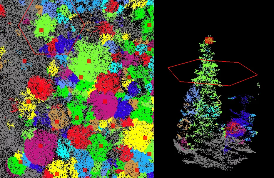
GREENVALLEY LiDAR360 Framework +Forestry +Terrain
€5,343.10*
E412095
GREENVALLEY LiDAR360 Framework +Forestry +Terrain
 image 1_EPOTRONIC")
 image 2_EPOTRONIC")
DJI Terra Cluster Permanent 1 Set (3nodes)
€23,600.00*
420099
DJI Terra: Digitalisieren Sie die Welt
Analysieren und visualisieren Sie Ihre Umgebung mit DJI Terra, einer benutzerfreundlichen Kartierungslösung für Branchenprofis zur professionellen Erzeugung digitaler Daten aus echten Szenarien.
In nur wenigen Schritten lassen sich komplexe Flugaufträge automatisieren, was die Erstellung von Karten und Modellen für weitere Analysen stark vereinfacht.
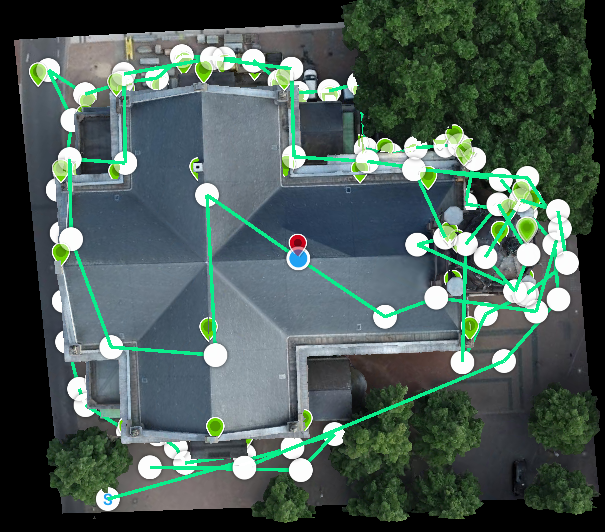
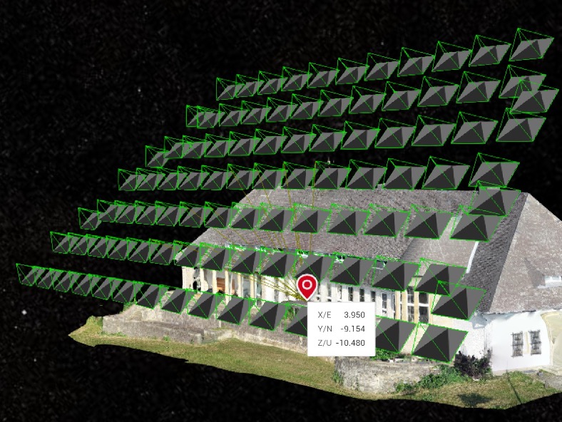
Wenn Präzision unerlässlich ist und eine hohe Detailgenauigkeit unverzichtbar ist, bieten Flugaufträge mit Schrägaufnahmen die Möglichkeit detailgetreue 3D-Modelle zu erstellen. Hierbei nimmt die Kamera Bilder aus einem Neigungswinkel auf, um ein noch schärferes und detaillierteres Bild des Zielobjekts zu erhalten.
Erstellen Sie effiziente Flugrouten mit vordefinierten Aktionen an den jeweiligen Wegpunkten. Schlüsselfunktionen wie beispielsweise Geschwindigkeit, Flughöhe und Gimbal-Ausrichtung können vor dem Flug festgelegt werden. Für komplexere Flugaufträge und Flüge in beengten Verhältnissen, die ein sehr hohes Maß an Detailgenauigkeit benötigen, steht jetzt eine 3D-Flugvisualisierung zur Verfügung, um Flüge in bestehenden 3D-Modellen zu planen und zu simulieren.
Echtzeit-Mapping
Mit der Echtzeit-Mapping-Funktion können Sie schnell und in Echtzeit ein 2D-Orthomosaik des ausgewählten Bereichs der Flugmission erstellen. Dies ist nicht nur ideal für die Erstellung detaillierter Flugrouten in abgelegenen Gebieten, sondern auch für zeitkritische Missionen, die eine schnelle Entscheidung vor Ort erfordern.
2D-Rekonstruktion
Generieren Sie hochauflösende Orthomosaik, damit Sie detaillierte und genaue Messergebnisse für alle Ihre kritischen Projekte erhalten.
3D-Rekonstruktion
Erhalten Sie scharfe und realistische Darstellungen Ihrer Umgebung in verschiedenen industriellen Anwendungen, sei es bei der Unfallrekonstruktion, der Verfolgung von Fortschritten bei großen Bauprojekten und vielem mehr.
Datenanalyse
2D&3D-Messung
Erfassen Sie wichtige Dimensionen über eine Vielzahl von Terrains mit einfach zu bedienenden Analysetools, die es Ihnen ermöglichen, eine Vielzahl von Messdaten basierend auf linearen, flächen- und volumetrischen Messungen zu erhalten.
Anmerkungen
Bearbeiten Sie Labels von Messungen an bestehenden Modellen, die zur Berichterstattung und Verbesserung der Kommunikation während laufender Projekte verwendet werden können.
Fotoinspektion
Überprüfen Sie jedes Foto des Modells genau, damit Sie alle kritischen Elemente in der realen Welt genau erkennen und hervorheben können.
Inspektion durch detaillierte Fotos
Für Details können Anwender auf eine bestimmte Stelle des Modells zoomen. Dies erleichtert die optimale Markierung von wichtigen Stellen für reale Inspektionen.
Terra Lizenzplan Cluster: 2D-Kartierungen in Echtzeit, Landwirtschaftliche Anwendungen, 2D-Rekonstruktion (Feld), Multispektrale 2D-Rekonstruktion (Stadt), KML-Datenimport, Ausgegebenes Koordinatensystem, ROI-Rekonstruktion, Bild-POS-Import, Multi-GPU-Rekonstruktion, 3D-Rekonstruktion, 3D-Planung von Flugaufträgen, 3D-Kartierungen in Echtzeit, Passpunkte (GCPs), Präzisionsoptimierung für LiDAR-Punktwolken, Energiewirtschaftliche Anwendungen, Detaillierte Inspektionen

AGISOFT Metashape Pro Floating 3 Licenses Pack
€20,499.00*
411783
Aus Agisoft PhotoScan wird Metashape!
Metashape übernimmt alle Funktionen von PhotoScan und bietet darüber hinaus noch viele weitere Anwendungsmöglichkeiten. Lizenzierte Benutzer von Agisoft Photoscan können, basierend auf der Software-Edition, ein kostenloses Upgrade auf Agisoft Metashape durchführen.
Agisoft Metashape ermöglicht die photogrammetrische Verarbeitung digitaler Bilddaten. Daraus generierte, räumliche 3D-Daten können für verschiedene GIS-Anwendungen, die Produktion und Dokumentation visueller Effekte sowie für indirekte Messungen verwendet werden.
Die Implementierung von Computer Vision Methoden führt zu einem intelligenten, automatisierten Verarbeitungssystem, das sowohl für Einsteiger als auch für Spezialisten viel zu bieten hat. Der Workflow kann auf zahlreiche, spezifische Anforderungen und Arten von Daten abgestimmt werden.
Agisoft Metashape gibt es in der Standard und Professional Edition.
Metashape Features:
Standard Edition
Photogrammetrische Triangulation (Dreiecksvermessung)
Dichte Punktwolkenbildung
3D: Generierung und Strukturierung
Panorama-Stitching
3D-Rekonstruktion für Daten, die von der gleichen Kameraposition/Kamerastation erfasst wurden
Pro Features (Alle Funktionen der Standard Edition sind enthalten)
Digitales Höhenmodell: DSM/DTM-Export
Export von georeferenzierten Orthomosaiken
Messungen: Entfernungen, Flächen, Volumen
Bodenkontrollpunkte: hochgenaue Vermessung
 image 1_EPOTRONIC")
 image 2_EPOTRONIC")
GREENVALLEY LiDAR360 Perpetual (Alle Module)
€10,568.97*
E007GLI
GVI Varianten:
ALL MODULES perpetual (lifelong)
GREENVALLEY LiDAR360 Perpetual (Alle Module)

AGISOFT Metashape Pro 3 Licenses Pack
€10,499.00*
411684
Aus Agisoft PhotoScan wird Metashape!
Metashape übernimmt alle Funktionen von PhotoScan und bietet darüber hinaus noch viele weitere Anwendungsmöglichkeiten. Lizenzierte Benutzer von Agisoft Photoscan können, basierend auf der Software-Edition, ein kostenloses Upgrade auf Agisoft Metashape durchführen.
Agisoft Metashape ermöglicht die photogrammetrische Verarbeitung digitaler Bilddaten. Daraus generierte, räumliche 3D-Daten können für verschiedene GIS-Anwendungen, die Produktion und Dokumentation visueller Effekte sowie für indirekte Messungen verwendet werden.
Die Implementierung von Computer Vision Methoden führt zu einem intelligenten, automatisierten Verarbeitungssystem, das sowohl für Einsteiger als auch für Spezialisten viel zu bieten hat. Der Workflow kann auf zahlreiche, spezifische Anforderungen und Arten von Daten abgestimmt werden.
Agisoft Metashape gibt es in der Standard und Professional Edition.
Metashape Features:
Standard Edition
Photogrammetrische Triangulation (Dreiecksvermessung)
Dichte Punktwolkenbildung
3D: Generierung und Strukturierung
Panorama-Stitching
3D-Rekonstruktion für Daten, die von der gleichen Kameraposition/Kamerastation erfasst wurden
Pro Features (Alle Funktionen der Standard Edition sind enthalten)
Digitales Höhenmodell: DSM/DTM-Export
Export von georeferenzierten Orthomosaiken
Messungen: Entfernungen, Flächen, Volumen
Bodenkontrollpunkte: hochgenaue Vermessung
 image 1_EPOTRONIC")
 image 2_EPOTRONIC")
GREENVALLEY LiDAR360 MLS Professional (Alle Module)
€10,438.60*
E015GLI
GREENVALLEY LiDAR360 MLS Professional (Alle Module)


New


GREENVALLEY LiDAR360 Framework Concurrent License
€9,214.49*
E016GLI
GVI Varianten:
FRAMEWORK concurrent licence (Server)
GREENVALLEY LiDAR360 Framework Concurrent License
Server version!

AGISOFT Metashape Pro Floating Single
€7,499.00*
411776
Aus Agisoft PhotoScan wird Metashape!
Metashape übernimmt alle Funktionen von PhotoScan und bietet darüber hinaus noch viele weitere Anwendungsmöglichkeiten. Lizenzierte Benutzer von Agisoft Photoscan können, basierend auf der Software-Edition, ein kostenloses Upgrade auf Agisoft Metashape durchführen.
Agisoft Metashape ermöglicht die photogrammetrische Verarbeitung digitaler Bilddaten. Daraus generierte, räumliche 3D-Daten können für verschiedene GIS-Anwendungen, die Produktion und Dokumentation visueller Effekte sowie für indirekte Messungen verwendet werden.
Die Implementierung von Computer Vision Methoden führt zu einem intelligenten, automatisierten Verarbeitungssystem, das sowohl für Einsteiger als auch für Spezialisten viel zu bieten hat. Der Workflow kann auf zahlreiche, spezifische Anforderungen und Arten von Daten abgestimmt werden.
Agisoft Metashape gibt es in der Standard und Professional Edition.
Metashape Features:
Standard Edition
Photogrammetrische Triangulation (Dreiecksvermessung)
Dichte Punktwolkenbildung
3D: Generierung und Strukturierung
Panorama-Stitching
3D-Rekonstruktion für Daten, die von der gleichen Kameraposition/Kamerastation erfasst wurden
Pro Features (Alle Funktionen der Standard Edition sind enthalten)
Digitales Höhenmodell: DSM/DTM-Export
Export von georeferenzierten Orthomosaiken
Messungen: Entfernungen, Flächen, Volumen
Bodenkontrollpunkte: hochgenaue Vermessung


VIRTUAL SURVEYOR Peak 3 Years
€6,497.40*
E004VPE
From drone to CAD in a few clicks. Virtual Surveyor provides surveyors with an intuitive desktop software application, enabling them to rapidly create traditional surveying deliverables when using drones.
Using drones represents a big difference in the type of data used traditionally by surveyors. Virtual Surveyor software packages incorporate traditional methods and deliverables to provide an intuitive experience for surveyors with little or no drone experience.
Virtual Surveyor works with point clouds, orthophotos and elevation models generated by drones to create deliverables traditionally created by surveyors.
The peak version is ideal when working with larger projects, and tracking progress over time.
Virtual Surveyor features:
Valley
Import Orthos & DSMs
Import CAD
Convert Point Clouds
Draw Points & Lines
Mosaic Tools
Export to CAD
Ridge
All Valley Features
Create Surfaces
Regular Point Grids
Advanced Editing
Modify Terrain
Stockpile Volumes
Peak
All Ridge Features
Terrain States
Cut/Fill Maps
Remove Objects
Breakline Tools
Intelligent Point Grids

AGISOFT Metashape Pro Floating EDU 10Licenses Pack
€6,199.00*
411851
Aus Agisoft PhotoScan wird Metashape!
Metashape übernimmt alle Funktionen von PhotoScan und bietet darüber hinaus noch viele weitere Anwendungsmöglichkeiten. Lizenzierte Benutzer von Agisoft Photoscan können, basierend auf der Software-Edition, ein kostenloses Upgrade auf Agisoft Metashape durchführen.
Agisoft Metashape ermöglicht die photogrammetrische Verarbeitung digitaler Bilddaten. Daraus generierte, räumliche 3D-Daten können für verschiedene GIS-Anwendungen, die Produktion und Dokumentation visueller Effekte sowie für indirekte Messungen verwendet werden.
Die Implementierung von Computer Vision Methoden führt zu einem intelligenten, automatisierten Verarbeitungssystem, das sowohl für Einsteiger als auch für Spezialisten viel zu bieten hat. Der Workflow kann auf zahlreiche, spezifische Anforderungen und Arten von Daten abgestimmt werden.
Agisoft Metashape gibt es in der Standard und Professional Edition.
Metashape Features:
Standard Edition
Photogrammetrische Triangulation (Dreiecksvermessung)
Dichte Punktwolkenbildung
3D: Generierung und Strukturierung
Panorama-Stitching
3D-Rekonstruktion für Daten, die von der gleichen Kameraposition/Kamerastation erfasst wurden
Pro Features (Alle Funktionen der Standard Edition sind enthalten)
Digitales Höhenmodell: DSM/DTM-Export
Export von georeferenzierten Orthomosaiken
Messungen: Entfernungen, Flächen, Volumen
Bodenkontrollpunkte: hochgenaue Vermessung


GREENVALLEY LiDAR360 Framework Perpetual
€4,760.00*
E010GLI
GVI Varianten:
FRAMEWORK perpetual (for life)
GREENVALLEY LiDAR360 Framework Perpetual


GREENVALLEY LiDAR360 Framework Annual
€4,623.92*
E009GLI
GVI Varianten:
FRAMEWORK yearly subscription
GREENVALLEY LiDAR360 Framework Annual

AGISOFT Metashape Pro Floating EDU 5 Licenses Pack
€4,499.00*
411844
Aus Agisoft PhotoScan wird Metashape!
Metashape übernimmt alle Funktionen von PhotoScan und bietet darüber hinaus noch viele weitere Anwendungsmöglichkeiten. Lizenzierte Benutzer von Agisoft Photoscan können, basierend auf der Software-Edition, ein kostenloses Upgrade auf Agisoft Metashape durchführen.
Agisoft Metashape ermöglicht die photogrammetrische Verarbeitung digitaler Bilddaten. Daraus generierte, räumliche 3D-Daten können für verschiedene GIS-Anwendungen, die Produktion und Dokumentation visueller Effekte sowie für indirekte Messungen verwendet werden.
Die Implementierung von Computer Vision Methoden führt zu einem intelligenten, automatisierten Verarbeitungssystem, das sowohl für Einsteiger als auch für Spezialisten viel zu bieten hat. Der Workflow kann auf zahlreiche, spezifische Anforderungen und Arten von Daten abgestimmt werden.
Agisoft Metashape gibt es in der Standard und Professional Edition.
Metashape Features:
Standard Edition
Photogrammetrische Triangulation (Dreiecksvermessung)
Dichte Punktwolkenbildung
3D: Generierung und Strukturierung
Panorama-Stitching
3D-Rekonstruktion für Daten, die von der gleichen Kameraposition/Kamerastation erfasst wurden
Pro Features (Alle Funktionen der Standard Edition sind enthalten)
Digitales Höhenmodell: DSM/DTM-Export
Export von georeferenzierten Orthomosaiken
Messungen: Entfernungen, Flächen, Volumen
Bodenkontrollpunkte: hochgenaue Vermessung


VIRTUAL SURVEYOR Peak 2 Years
€4,408.95*
E003VPE
From drone to CAD in a few clicks. Virtual Surveyor provides surveyors with an intuitive desktop software application, enabling them to rapidly create traditional surveying deliverables when using drones.
Using drones represents a big difference in the type of data used traditionally by surveyors. Virtual Surveyor software packages incorporate traditional methods and deliverables to provide an intuitive experience for surveyors with little or no drone experience.
Virtual Surveyor works with point clouds, orthophotos and elevation models generated by drones to create deliverables traditionally created by surveyors.
The peak version is ideal when working with larger projects, and tracking progress over time.
Virtual Surveyor features:
Valley
Import Orthos & DSMs
Import CAD
Convert Point Clouds
Draw Points & Lines
Mosaic Tools
Export to CAD
Ridge
All Valley Features
Create Surfaces
Regular Point Grids
Advanced Editing
Modify Terrain
Stockpile Volumes
Peak
All Ridge Features
Terrain States
Cut/Fill Maps
Remove Objects
Breakline Tools
Intelligent Point Grids


VIRTUAL SURVEYOR Ridge 3 Years
€4,165.00*
E004VRI
From drone to CAD in a few clicks. Virtual Surveyor provides surveyors with an intuitive desktop software application, enabling them to rapidly create traditional surveying deliverables when using drones.
Using drones represents a big difference in the type of data used traditionally by surveyors. Virtual Surveyor software packages incorporate traditional methods and deliverables to provide an intuitive experience for surveyors with little or no drone experience.
Virtual Surveyor works with point clouds, orthophotos and elevation models generated by drones to create deliverables traditionally created by surveyors.
The Ridge version is good for creating advanced topographic and quantity surveys.
Virtual Surveyor features:
Valley
Import Orthos & DSMs
Import CAD
Convert Point Clouds
Draw Points & Lines
Mosaic Tools
Export to CAD
Ridge
All Valley Features
Create Surfaces
Regular Point Grids
Advanced Editing
Modify Terrain
Stockpile Volumes
Peak
All Ridge Features
Terrain States
Cut/Fill Maps
Remove Objects
Breakline Tools
Intelligent Point Grids
 image 1_EPOTRONIC")
 image 2_EPOTRONIC")
GREENVALLEY LiDAR360 Annual (Alle Module)
€4,080.00*
E008GLI
GVI Varianten:
ALL MODULES yearly subscription
GREENVALLEY LiDAR360 Annual (Alle Module)

AGISOFT Metashape Pro Single
€3,799.00*
411677
Aus Agisoft PhotoScan wird Metashape!
Metashape übernimmt alle Funktionen von PhotoScan und bietet darüber hinaus noch viele weitere Anwendungsmöglichkeiten. Lizenzierte Benutzer von Agisoft Photoscan können, basierend auf der Software-Edition, ein kostenloses Upgrade auf Agisoft Metashape durchführen.
Agisoft Metashape ermöglicht die photogrammetrische Verarbeitung digitaler Bilddaten. Daraus generierte, räumliche 3D-Daten können für verschiedene GIS-Anwendungen, die Produktion und Dokumentation visueller Effekte sowie für indirekte Messungen verwendet werden.
Die Implementierung von Computer Vision Methoden führt zu einem intelligenten, automatisierten Verarbeitungssystem, das sowohl für Einsteiger als auch für Spezialisten viel zu bieten hat. Der Workflow kann auf zahlreiche, spezifische Anforderungen und Arten von Daten abgestimmt werden.
Agisoft Metashape gibt es in der Standard und Professional Edition.
Metashape Features:
Standard Edition
Photogrammetrische Triangulation (Dreiecksvermessung)
Dichte Punktwolkenbildung
3D: Generierung und Strukturierung
Panorama-Stitching
3D-Rekonstruktion für Daten, die von der gleichen Kameraposition/Kamerastation erfasst wurden
Pro Features (Alle Funktionen der Standard Edition sind enthalten)
Digitales Höhenmodell: DSM/DTM-Export
Export von georeferenzierten Orthomosaiken
Messungen: Entfernungen, Flächen, Volumen
Bodenkontrollpunkte: hochgenaue Vermessung

AGISOFT Metashape Pro Floating EDU 3 Licenses Pack
€3,199.00*
411837
Aus Agisoft PhotoScan wird Metashape!
Metashape übernimmt alle Funktionen von PhotoScan und bietet darüber hinaus noch viele weitere Anwendungsmöglichkeiten. Lizenzierte Benutzer von Agisoft Photoscan können, basierend auf der Software-Edition, ein kostenloses Upgrade auf Agisoft Metashape durchführen.
Agisoft Metashape ermöglicht die photogrammetrische Verarbeitung digitaler Bilddaten. Daraus generierte, räumliche 3D-Daten können für verschiedene GIS-Anwendungen, die Produktion und Dokumentation visueller Effekte sowie für indirekte Messungen verwendet werden.
Die Implementierung von Computer Vision Methoden führt zu einem intelligenten, automatisierten Verarbeitungssystem, das sowohl für Einsteiger als auch für Spezialisten viel zu bieten hat. Der Workflow kann auf zahlreiche, spezifische Anforderungen und Arten von Daten abgestimmt werden.
Agisoft Metashape gibt es in der Standard und Professional Edition.
Metashape Features:
Standard Edition
Photogrammetrische Triangulation (Dreiecksvermessung)
Dichte Punktwolkenbildung
3D: Generierung und Strukturierung
Panorama-Stitching
3D-Rekonstruktion für Daten, die von der gleichen Kameraposition/Kamerastation erfasst wurden
Pro Features (Alle Funktionen der Standard Edition sind enthalten)
Digitales Höhenmodell: DSM/DTM-Export
Export von georeferenzierten Orthomosaiken
Messungen: Entfernungen, Flächen, Volumen
Bodenkontrollpunkte: hochgenaue Vermessung
 image 1_EPOTRONIC")
 image 2_EPOTRONIC")
DJI Terra Electricity 1 Year (1 Device)
€3,150.00*
422529
DJI Terra: Digitalisieren Sie die Welt
Analysieren und visualisieren Sie Ihre Umgebung mit DJI Terra, einer benutzerfreundlichen Kartierungslösung für Branchenprofis zur professionellen Erzeugung digitaler Daten aus echten Szenarien.
In nur wenigen Schritten lassen sich komplexe Flugaufträge automatisieren, was die Erstellung von Karten und Modellen für weitere Analysen stark vereinfacht.
Wenn Präzision unerlässlich ist und eine hohe Detailgenauigkeit unverzichtbar ist, bieten Flugaufträge mit Schrägaufnahmen die Möglichkeit detailgetreue 3D-Modelle zu erstellen. Hierbei nimmt die Kamera Bilder aus einem Neigungswinkel auf, um ein noch schärferes und detaillierteres Bild des Zielobjekts zu erhalten.
Erstellen Sie effiziente Flugrouten mit vordefinierten Aktionen an den jeweiligen Wegpunkten. Schlüsselfunktionen wie beispielsweise Geschwindigkeit, Flughöhe und Gimbal-Ausrichtung können vor dem Flug festgelegt werden. Für komplexere Flugaufträge und Flüge in beengten Verhältnissen, die ein sehr hohes Maß an Detailgenauigkeit benötigen, steht jetzt eine 3D-Flugvisualisierung zur Verfügung, um Flüge in bestehenden 3D-Modellen zu planen und zu simulieren.
Echtzeit-Mapping
Mit der Echtzeit-Mapping-Funktion können Sie schnell und in Echtzeit ein 2D-Orthomosaik des ausgewählten Bereichs der Flugmission erstellen. Dies ist nicht nur ideal für die Erstellung detaillierter Flugrouten in abgelegenen Gebieten, sondern auch für zeitkritische Missionen, die eine schnelle Entscheidung vor Ort erfordern.
2D-Rekonstruktion
Generieren Sie hochauflösende Orthomosaik, damit Sie detaillierte und genaue Messergebnisse für alle Ihre kritischen Projekte erhalten.
3D-Rekonstruktion
Erhalten Sie scharfe und realistische Darstellungen Ihrer Umgebung in verschiedenen industriellen Anwendungen, sei es bei der Unfallrekonstruktion, der Verfolgung von Fortschritten bei großen Bauprojekten und vielem mehr.
Datenanalyse
2D&3D-Messung
Erfassen Sie wichtige Dimensionen über eine Vielzahl von Terrains mit einfach zu bedienenden Analysetools, die es Ihnen ermöglichen, eine Vielzahl von Messdaten basierend auf linearen, flächen- und volumetrischen Messungen zu erhalten.
Anmerkungen
Bearbeiten Sie Labels von Messungen an bestehenden Modellen, die zur Berichterstattung und Verbesserung der Kommunikation während laufender Projekte verwendet werden können.
Fotoinspektion
Überprüfen Sie jedes Foto des Modells genau, damit Sie alle kritischen Elemente in der realen Welt genau erkennen und hervorheben können.
Terra Lizenzplan Electricity: 2D-Kartierungen in Echtzeit, Landwirtschaftliche Anwendungen, 2D-Rekonstruktion (Feld), Multispektrale 2D-Rekonstruktion (Stadt), KML-Datenimport, Ausgegebenes Koordinatensystem, ROI-Rekonstruktion, Bild-POS-Import, Multi-GPU-Rekonstruktion, 3D-Rekonstruktion, 3D-Planung von Flugaufträgen, 3D-Kartierungen in Echtzeit, Passpunkte (GCPs), Präzisionsoptimierung für LiDAR-Punktwolken, Energiewirtschaftliche Anwendungen, Detaillierte Inspektionen

AGISOFT Metashape Pro Educational 10 Licenses Pack
€3,099.00*
411752
Aus Agisoft PhotoScan wird Metashape!
Metashape übernimmt alle Funktionen von PhotoScan und bietet darüber hinaus noch viele weitere Anwendungsmöglichkeiten. Lizenzierte Benutzer von Agisoft Photoscan können, basierend auf der Software-Edition, ein kostenloses Upgrade auf Agisoft Metashape durchführen.
Agisoft Metashape ermöglicht die photogrammetrische Verarbeitung digitaler Bilddaten. Daraus generierte, räumliche 3D-Daten können für verschiedene GIS-Anwendungen, die Produktion und Dokumentation visueller Effekte sowie für indirekte Messungen verwendet werden.
Die Implementierung von Computer Vision Methoden führt zu einem intelligenten, automatisierten Verarbeitungssystem, das sowohl für Einsteiger als auch für Spezialisten viel zu bieten hat. Der Workflow kann auf zahlreiche, spezifische Anforderungen und Arten von Daten abgestimmt werden.
Agisoft Metashape gibt es in der Standard und Professional Edition.
Metashape Features:
Standard Edition
Photogrammetrische Triangulation (Dreiecksvermessung)
Dichte Punktwolkenbildung
3D: Generierung und Strukturierung
Panorama-Stitching
3D-Rekonstruktion für Daten, die von der gleichen Kameraposition/Kamerastation erfasst wurden
Pro Features (Alle Funktionen der Standard Edition sind enthalten)
Digitales Höhenmodell: DSM/DTM-Export
Export von georeferenzierten Orthomosaiken
Messungen: Entfernungen, Flächen, Volumen
Bodenkontrollpunkte: hochgenaue Vermessung


VIRTUAL SURVEYOR Ridge 2 Years
€2,826.25*
E003VRI
From drone to CAD in a few clicks. Virtual Surveyor provides surveyors with an intuitive desktop software application, enabling them to rapidly create traditional surveying deliverables when using drones.
Using drones represents a big difference in the type of data used traditionally by surveyors. Virtual Surveyor software packages incorporate traditional methods and deliverables to provide an intuitive experience for surveyors with little or no drone experience.
Virtual Surveyor works with point clouds, orthophotos and elevation models generated by drones to create deliverables traditionally created by surveyors.
The Ridge version is good for creating advanced topographic and quantity surveys.
Virtual Surveyor features:
Valley
Import Orthos & DSMs
Import CAD
Convert Point Clouds
Draw Points & Lines
Mosaic Tools
Export to CAD
Ridge
All Valley Features
Create Surfaces
Regular Point Grids
Advanced Editing
Modify Terrain
Stockpile Volumes
Peak
All Ridge Features
Terrain States
Cut/Fill Maps
Remove Objects
Breakline Tools
Intelligent Point Grids


UgCS Universal ground control Software Enterprise
€2,606.00*
410922
Geeignet für Unternehmen, die eine Flotte von Drohnen unterschiedlicher Hersteller betreiben und eine einheitliche Bodenstation benötigen. ADS-B-Transponder-Unterstützung, Multi-Node-Deployment, ermöglicht den Betrieb eines zentralen Servers mit unbegrenzter Anbindung von UgCS-Clients.

DJI Terra Upgrade and Maintenance fee
€2,360.00*
420112
DJI Terra: Digitalisieren Sie die Welt
Analysieren und visualisieren Sie Ihre Umgebung mit DJI Terra, einer benutzerfreundlichen Kartierungslösung für Branchenprofis zur professionellen Erzeugung digitaler Daten aus echten Szenarien.
In nur wenigen Schritten lassen sich komplexe Flugaufträge automatisieren, was die Erstellung von Karten und Modellen für weitere Analysen stark vereinfacht.
Wenn Präzision unerlässlich ist und eine hohe Detailgenauigkeit unverzichtbar ist, bieten Flugaufträge mit Schrägaufnahmen die Möglichkeit detailgetreue 3D-Modelle zu erstellen. Hierbei nimmt die Kamera Bilder aus einem Neigungswinkel auf, um ein noch schärferes und detaillierteres Bild des Zielobjekts zu erhalten.
Erstellen Sie effiziente Flugrouten mit vordefinierten Aktionen an den jeweiligen Wegpunkten. Schlüsselfunktionen wie beispielsweise Geschwindigkeit, Flughöhe und Gimbal-Ausrichtung können vor dem Flug festgelegt werden. Für komplexere Flugaufträge und Flüge in beengten Verhältnissen, die ein sehr hohes Maß an Detailgenauigkeit benötigen, steht jetzt eine 3D-Flugvisualisierung zur Verfügung, um Flüge in bestehenden 3D-Modellen zu planen und zu simulieren.
Echtzeit-Mapping
Mit der Echtzeit-Mapping-Funktion können Sie schnell und in Echtzeit ein 2D-Orthomosaik des ausgewählten Bereichs der Flugmission erstellen. Dies ist nicht nur ideal für die Erstellung detaillierter Flugrouten in abgelegenen Gebieten, sondern auch für zeitkritische Missionen, die eine schnelle Entscheidung vor Ort erfordern.
2D-Rekonstruktion
Generieren Sie hochauflösende Orthomosaik, damit Sie detaillierte und genaue Messergebnisse für alle Ihre kritischen Projekte erhalten.
3D-Rekonstruktion
Erhalten Sie scharfe und realistische Darstellungen Ihrer Umgebung in verschiedenen industriellen Anwendungen, sei es bei der Unfallrekonstruktion, der Verfolgung von Fortschritten bei großen Bauprojekten und vielem mehr.
Datenanalyse
2D&3D-Messung
Erfassen Sie wichtige Dimensionen über eine Vielzahl von Terrains mit einfach zu bedienenden Analysetools, die es Ihnen ermöglichen, eine Vielzahl von Messdaten basierend auf linearen, flächen- und volumetrischen Messungen zu erhalten.
Anmerkungen
Bearbeiten Sie Labels von Messungen an bestehenden Modellen, die zur Berichterstattung und Verbesserung der Kommunikation während laufender Projekte verwendet werden können.
Fotoinspektion
Überprüfen Sie jedes Foto des Modells genau, damit Sie alle kritischen Elemente in der realen Welt genau erkennen und hervorheben können.
Inspektion durch detaillierte Fotos
Für Details können Anwender auf eine bestimmte Stelle des Modells zoomen. Dies erleichtert die optimale Markierung von wichtigen Stellen für reale Inspektionen.
Terra Lizenzplan Cluster: 2D-Kartierungen in Echtzeit, Landwirtschaftliche Anwendungen, 2D-Rekonstruktion (Feld), Multispektrale 2D-Rekonstruktion (Stadt), KML-Datenimport, Ausgegebenes Koordinatensystem, ROI-Rekonstruktion, Bild-POS-Import, Multi-GPU-Rekonstruktion, 3D-Rekonstruktion, 3D-Planung von Flugaufträgen, 3D-Kartierungen in Echtzeit, Passpunkte (GCPs), Präzisionsoptimierung für LiDAR-Punktwolken, Energiewirtschaftliche Anwendungen, Detaillierte Inspektionen
Bitte beachten Sie, dass Sie hiermit DJI Terra Upgrade and Maintenance fee erwerben.


DJI Terra Cluster additional node package
€2,360.00*
420105
DJI Terra: Digitalisieren Sie die Welt
Analysieren und visualisieren Sie Ihre Umgebung mit DJI Terra, einer benutzerfreundlichen Kartierungslösung für Branchenprofis zur professionellen Erzeugung digitaler Daten aus echten Szenarien.
In nur wenigen Schritten lassen sich komplexe Flugaufträge automatisieren, was die Erstellung von Karten und Modellen für weitere Analysen stark vereinfacht.
Wenn Präzision unerlässlich ist und eine hohe Detailgenauigkeit unverzichtbar ist, bieten Flugaufträge mit Schrägaufnahmen die Möglichkeit detailgetreue 3D-Modelle zu erstellen. Hierbei nimmt die Kamera Bilder aus einem Neigungswinkel auf, um ein noch schärferes und detaillierteres Bild des Zielobjekts zu erhalten.
Erstellen Sie effiziente Flugrouten mit vordefinierten Aktionen an den jeweiligen Wegpunkten. Schlüsselfunktionen wie beispielsweise Geschwindigkeit, Flughöhe und Gimbal-Ausrichtung können vor dem Flug festgelegt werden. Für komplexere Flugaufträge und Flüge in beengten Verhältnissen, die ein sehr hohes Maß an Detailgenauigkeit benötigen, steht jetzt eine 3D-Flugvisualisierung zur Verfügung, um Flüge in bestehenden 3D-Modellen zu planen und zu simulieren.
Echtzeit-Mapping
Mit der Echtzeit-Mapping-Funktion können Sie schnell und in Echtzeit ein 2D-Orthomosaik des ausgewählten Bereichs der Flugmission erstellen. Dies ist nicht nur ideal für die Erstellung detaillierter Flugrouten in abgelegenen Gebieten, sondern auch für zeitkritische Missionen, die eine schnelle Entscheidung vor Ort erfordern.
2D-Rekonstruktion
Generieren Sie hochauflösende Orthomosaik, damit Sie detaillierte und genaue Messergebnisse für alle Ihre kritischen Projekte erhalten.
3D-Rekonstruktion
Erhalten Sie scharfe und realistische Darstellungen Ihrer Umgebung in verschiedenen industriellen Anwendungen, sei es bei der Unfallrekonstruktion, der Verfolgung von Fortschritten bei großen Bauprojekten und vielem mehr.
Datenanalyse
2D&3D-Messung
Erfassen Sie wichtige Dimensionen über eine Vielzahl von Terrains mit einfach zu bedienenden Analysetools, die es Ihnen ermöglichen, eine Vielzahl von Messdaten basierend auf linearen, flächen- und volumetrischen Messungen zu erhalten.
Anmerkungen
Bearbeiten Sie Labels von Messungen an bestehenden Modellen, die zur Berichterstattung und Verbesserung der Kommunikation während laufender Projekte verwendet werden können.
Fotoinspektion
Überprüfen Sie jedes Foto des Modells genau, damit Sie alle kritischen Elemente in der realen Welt genau erkennen und hervorheben können.
Inspektion durch detaillierte Fotos
Für Details können Anwender auf eine bestimmte Stelle des Modells zoomen. Dies erleichtert die optimale Markierung von wichtigen Stellen für reale Inspektionen.
Terra Lizenzplan Cluster: 2D-Kartierungen in Echtzeit, Landwirtschaftliche Anwendungen, 2D-Rekonstruktion (Feld), Multispektrale 2D-Rekonstruktion (Stadt), KML-Datenimport, Ausgegebenes Koordinatensystem, ROI-Rekonstruktion, Bild-POS-Import, Multi-GPU-Rekonstruktion, 3D-Rekonstruktion, 3D-Planung von Flugaufträgen, 3D-Kartierungen in Echtzeit, Passpunkte (GCPs), Präzisionsoptimierung für LiDAR-Punktwolken, Energiewirtschaftliche Anwendungen, Detaillierte Inspektionen


VIRTUAL SURVEYOR Peak 1 Year
€2,313.36*
E002VPE
From drone to CAD in a few clicks. Virtual Surveyor provides surveyors with an intuitive desktop software application, enabling them to rapidly create traditional surveying deliverables when using drones.
Using drones represents a big difference in the type of data used traditionally by surveyors. Virtual Surveyor software packages incorporate traditional methods and deliverables to provide an intuitive experience for surveyors with little or no drone experience.
Virtual Surveyor works with point clouds, orthophotos and elevation models generated by drones to create deliverables traditionally created by surveyors.
The peak version is ideal when working with larger projects, and tracking progress over time.
Virtual Surveyor features:
Valley
Import Orthos & DSMs
Import CAD
Convert Point Clouds
Draw Points & Lines
Mosaic Tools
Export to CAD
Ridge
All Valley Features
Create Surfaces
Regular Point Grids
Advanced Editing
Modify Terrain
Stockpile Volumes
Peak
All Ridge Features
Terrain States
Cut/Fill Maps
Remove Objects
Breakline Tools
Intelligent Point Grids


GREENVALLEY LiDAR360 Forestry Perpetual
€2,311.97*
E012GLI
GVI Varianten:
FORESTRY add-on perpetual (lifelong)
GREENVALLEY LiDAR360 Forestry Perpetual
Für dieses Add-on benötigen Sie mindestens die Framework Version.


GREENVALLEY LiDAR360 Terrain Perpetual
€2,311.96*
E011GLI
GVI Varianten:
TERRAIN add-on perpetual (lifelong)
GREENVALLEY LiDAR360 Terrain Perpetual
Für dieses Add-on benötigen Sie mindestens die Framework Version.

AGISOFT Metashape Pro Educational 5 Licenses Pack
€2,249.00*
411745
Aus Agisoft PhotoScan wird Metashape!
Metashape übernimmt alle Funktionen von PhotoScan und bietet darüber hinaus noch viele weitere Anwendungsmöglichkeiten. Lizenzierte Benutzer von Agisoft Photoscan können, basierend auf der Software-Edition, ein kostenloses Upgrade auf Agisoft Metashape durchführen.
Agisoft Metashape ermöglicht die photogrammetrische Verarbeitung digitaler Bilddaten. Daraus generierte, räumliche 3D-Daten können für verschiedene GIS-Anwendungen, die Produktion und Dokumentation visueller Effekte sowie für indirekte Messungen verwendet werden.
Die Implementierung von Computer Vision Methoden führt zu einem intelligenten, automatisierten Verarbeitungssystem, das sowohl für Einsteiger als auch für Spezialisten viel zu bieten hat. Der Workflow kann auf zahlreiche, spezifische Anforderungen und Arten von Daten abgestimmt werden.
Agisoft Metashape gibt es in der Standard und Professional Edition.
Metashape Features:
Standard Edition
Photogrammetrische Triangulation (Dreiecksvermessung)
Dichte Punktwolkenbildung
3D: Generierung und Strukturierung
Panorama-Stitching
3D-Rekonstruktion für Daten, die von der gleichen Kameraposition/Kamerastation erfasst wurden
Pro Features (Alle Funktionen der Standard Edition sind enthalten)
Digitales Höhenmodell: DSM/DTM-Export
Export von georeferenzierten Orthomosaiken
Messungen: Entfernungen, Flächen, Volumen
Bodenkontrollpunkte: hochgenaue Vermessung

AGISOFT Metashape Pro Educational 3 Licenses Pack
€1,599.00*
411738
Aus Agisoft PhotoScan wird Metashape!
Metashape übernimmt alle Funktionen von PhotoScan und bietet darüber hinaus noch viele weitere Anwendungsmöglichkeiten. Lizenzierte Benutzer von Agisoft Photoscan können, basierend auf der Software-Edition, ein kostenloses Upgrade auf Agisoft Metashape durchführen.
Agisoft Metashape ermöglicht die photogrammetrische Verarbeitung digitaler Bilddaten. Daraus generierte, räumliche 3D-Daten können für verschiedene GIS-Anwendungen, die Produktion und Dokumentation visueller Effekte sowie für indirekte Messungen verwendet werden.
Die Implementierung von Computer Vision Methoden führt zu einem intelligenten, automatisierten Verarbeitungssystem, das sowohl für Einsteiger als auch für Spezialisten viel zu bieten hat. Der Workflow kann auf zahlreiche, spezifische Anforderungen und Arten von Daten abgestimmt werden.
Agisoft Metashape gibt es in der Standard und Professional Edition.
Metashape Features:
Standard Edition
Photogrammetrische Triangulation (Dreiecksvermessung)
Dichte Punktwolkenbildung
3D: Generierung und Strukturierung
Panorama-Stitching
3D-Rekonstruktion für Daten, die von der gleichen Kameraposition/Kamerastation erfasst wurden
Pro Features (Alle Funktionen der Standard Edition sind enthalten)
Digitales Höhenmodell: DSM/DTM-Export
Export von georeferenzierten Orthomosaiken
Messungen: Entfernungen, Flächen, Volumen
Bodenkontrollpunkte: hochgenaue Vermessung


VIRTUAL SURVEYOR Ridge 1 Year
€1,485.12*
E002VRI
From drone to CAD in a few clicks. Virtual Surveyor provides surveyors with an intuitive desktop software application, enabling them to rapidly create traditional surveying deliverables when using drones.
Using drones represents a big difference in the type of data used traditionally by surveyors. Virtual Surveyor software packages incorporate traditional methods and deliverables to provide an intuitive experience for surveyors with little or no drone experience.
Virtual Surveyor works with point clouds, orthophotos and elevation models generated by drones to create deliverables traditionally created by surveyors.
The peak version is ideal when working with larger projects, and tracking progress over time.
Virtual Surveyor features:
Valley
Import Orthos & DSMs
Import CAD
Convert Point Clouds
Draw Points & Lines
Mosaic Tools
Export to CAD
Ridge
All Valley Features
Create Surfaces
Regular Point Grids
Advanced Editing
Modify Terrain
Stockpile Volumes
Peak
All Ridge Features
Terrain States
Cut/Fill Maps
Remove Objects
Breakline Tools
Intelligent Point Grids


GREENVALLEY LiDAR360 Mine Perpetual
€1,431.21*
E014GLI
GVI Varianten:
MINING add-on perpetual (for life)
GREENVALLEY LiDAR360 Mine Perpetual
Für dieses Add-on benötigen Sie mindestens die Framework Version.


GREENVALLEY LiDAR360 Powerline Perpetual
€1,431.21*
E013GLI
GVI Varianten:
POWERLINE add-on perpetual (lifelong)
GREENVALLEY LiDAR360 Powerline Perpetual

AGISOFT Metashape Pro Floating EDU Single
€1,199.00*
411820
Aus Agisoft PhotoScan wird Metashape!
Metashape übernimmt alle Funktionen von PhotoScan und bietet darüber hinaus noch viele weitere Anwendungsmöglichkeiten. Lizenzierte Benutzer von Agisoft Photoscan können, basierend auf der Software-Edition, ein kostenloses Upgrade auf Agisoft Metashape durchführen.
Agisoft Metashape ermöglicht die photogrammetrische Verarbeitung digitaler Bilddaten. Daraus generierte, räumliche 3D-Daten können für verschiedene GIS-Anwendungen, die Produktion und Dokumentation visueller Effekte sowie für indirekte Messungen verwendet werden.
Die Implementierung von Computer Vision Methoden führt zu einem intelligenten, automatisierten Verarbeitungssystem, das sowohl für Einsteiger als auch für Spezialisten viel zu bieten hat. Der Workflow kann auf zahlreiche, spezifische Anforderungen und Arten von Daten abgestimmt werden.
Agisoft Metashape gibt es in der Standard und Professional Edition.
Metashape Features:
Standard Edition
Photogrammetrische Triangulation (Dreiecksvermessung)
Dichte Punktwolkenbildung
3D: Generierung und Strukturierung
Panorama-Stitching
3D-Rekonstruktion für Daten, die von der gleichen Kameraposition/Kamerastation erfasst wurden
Pro Features (Alle Funktionen der Standard Edition sind enthalten)
Digitales Höhenmodell: DSM/DTM-Export
Export von georeferenzierten Orthomosaiken
Messungen: Entfernungen, Flächen, Volumen
Bodenkontrollpunkte: hochgenaue Vermessung


DJI FlightHub 2 Professional Version 1 Year Plan
€1,179.00*
960887
DJI Matrice 350 RTK - Mit neuer Kraft voraus
Matrice 350 RTK ist weit mehr als das Upgrade eines Flaggschiffs. Diese Drohnenplattform der nächste Generation wird wieder einmal neue Maßstäbe für die gesamte Branche setzen. Dafür sorgen das erneuerte Videoübertragungssystem, die völlig neue Steuerung, das effizientere Akkusystem, umfangreichere Sicherheitsfunktionen sowie absolut robuste Nutzlast- und Erweiterungsmöglichkeiten. Erleben sie eine innovative Kraft, die sich mit jedem ihrer Lufteinsätze neu entfaltet.
Highlights:
55 Min. max. Flugzeit [1]
Schutzart IP55 [2]
DJI O3 Enterprise Transmission
DJI RC Fernsteuerung Plus
400 Akkuzyklen [3]
Sensorik & Positionierung in 6 Richtungen
Nachtsicht-FPV-Kamera
Unterstützt mehrere Nutzlasten
Mühelos kraftvolle Flugleistung
Die robust gebaute Matrice 350 RTK verfügt über einen leistungsstarken Antrieb, eine höhere Schutzart und absolut herausragende Flugeigenschaften, um selbst die unterschiedlichsten Herausforderungen ganz mühelos zu bewältigen.
Immer stabil dank neuem Übertragungssystem
Matrice 350 RTK kommt mit DJI O3 Enterprise Transmission System, welches 3-Kanal-1080p-HD-Live-Feeds [5] und eine Übertragungsreichweite von bis zu 20 km unterstützt. [6] Sowohl das Fluggerät als auch die Fernsteuerung verfügen über ein intelligentes 4-Antennen-Transceiversystem, das automatisch die beiden optimalen Antennen zur Signalübertragung auswählen kann, während alle vier Antennen simultan Signale empfangen. Auf diese Weise werden die Entstörungsfähigkeit und Übertragungsstabilität deutlich verbessert.
Neue Steuerung, mehr Möglichkeiten
DJI RC Plus ist mit einem leuchtstarken 7-Zoll-Bildschirm ausgestattet, unterstützt den dualen Betriebsmodus und wird standardmäßig mit externem WB37-Akku geliefert, der eine Laufzeit von bis zu sechs Stunden bietet und damit eine breitere Vielzahl anspruchsvollster Anforderungen abdeckt.
Bereit für extreme Bedingungen
Mit der Schutzart IP55 [2] ist die DJI RC Plus staub- und wasserdicht und funktioniert selbst bei schlechtem Wetter höchst zuverlässig. Die Betriebstemperatur beträgt -20 ° bis 50 ° C, was Einsätze rund um die Uhr ermöglicht, selbst in sehr heißen oder kalten Umgebungen.
DJI Pilot 2
Die DJI Pilot 2 App wurde weiter optimiert, um Einsatzart und Flugstatus noch klarer darzustellen. Die einfache und reibungslose Steuerung von Fluggerät und Nutzlast sorgt alles in allem für noch effizientere Einsätze.
Verbessertes Akkusystem: Neues Dual-System
Die Matrice 350 RTK ist mit dem neuen, dualen TB65 Akkusystem ausgestattet, welches Hot-Swapping unterstützt und mehrere Flüge ohne Ausschalten ermöglicht. Der Akku ist bis zu 400 Zyklen [3] aufladbar, wodurch die Kosten pro Einzelflug merklich reduziert werden.
Verbesserte Flugsicherheit
Arm-Verriegelungs-Erkennung
Die Matrice 350 RTK kommt mit einer neuen Funktion zur Verriegelungs-Erkennung, die das Risiko von entriegelten Gestellarm-Manschetten verhindert, sodass man sich noch unbesorgter auf jeden Flug konzentrieren kann.
Nachtsicht-FPV-Kamera
Die Matrice 350 RTK ist mit binokularen Sichtsystem sowie Infrarotsensorensystem für Erkennungs-, Positionierungs- und Hindernisvermeidung in sechs Richtungen ausgestattet und bietet so umfassenden Schutz während eines nächtlichen Flugs klar und deutlich. In Verbindung mit der PinPoint-Funktion ermöglicht sie zudem eine bessere Navigation für noch sicherere Flüge und einfachere Bedienung bei Nacht.
Sensorik & Positionierung in 6 Richtungen
Die Matrice 350 RTK ist mit binokularen Sichtsystem sowie Infrarotsensorensystem für Erkennungs-, Positionierungs- und Hindernisvermeidung in sechs Richtungen ausgestattet und bietet so umfassenden Schutz während des Fluges. [7]
CSM-Radar (Circular Scanning Millimeter-Wave-Radar) [8]
Mit dem installierten CSM-Radar kann die Matrice 350 RTK subtile Hindernisse im oberen Bereich oder innerhalb des horizontalen 360°-Bereichs erkennen und ihnen rechtzeitig ausweichen. [9] Die effektive Erfassungsreichweite beträgt bis zu 30 m, [10] was die Flugsicherheit weiter verbessert.
Vielschichtiges Redundanzsystem
Sowohl das Fluggerätesystem als auch das Sensorsystem der Matrice 350 RTK verfügen über ein Redundanzkonzept, das eine maximale Flugsicherheit gewährleistet, sodass selbst anspruchsvolle Einsatzumgebungen sicher gemeistert werden können.
Leistungsstarke Nutzlasten [8]
Die Matrice 350 RTK unterstützt einzeln abwärts gerichtete Gimbals, dual abwärts gerichtete Gimbals [11] sowie einzeln aufwärts gerichtete Gimbal [11] und bietet zudem eine offene E-Port-Schnittstelle. Mit einer maximalen Nutzlast von 2,7 kg kann das Fluggerät bis zu drei Lasten gleichzeitig transportieren und erfüllt damit die Anforderungen verschiedenster Betriebsszenarien, wie öffentliche Sicherheit, Inspektion und Kartierung.
* Bitte informieren sie sich stets über örtliche Vorschriften und Gesetze und halten sie sich strikt daran.
** Alle Daten wurden getestet mit einem Matrice 350 RTK-Produktionsmodell in einer kontrollierten Umgebung. Die tatsächlichen Werte können je nach Umgebung, Verwendung und Firmware-Version variieren.
*** Matrice 350 RTK muss vor der Verwendung mit der DJI Pilot 2 App aktiviert werden.
1. Gemessen mit Matrice 350 RTK, die mit ca. 8 m/s ohne Nutzlasten in einer windlosen Umgebung fliegt, bis der Akkustand 0 % erreicht hat. Die Angaben dienen nur als Referenz. Bitte beachte die Erinnerungen in der App bezüglich der tatsächlichen Nutzungszeit.
2. Gemessen in einer kontrollierten Umgebung. Die Schutzart ist nicht dauerhaft gültig und kann aufgrund von Produktverschleiß abnehmen.
3. Bis zu 400 Zyklen, wenn die Akkumulationsdauer des Akkustands ≥? 90 % weniger als 120 Tage innerhalb von 12 Monaten beträgt.
4. Gemessen mit den 2112 geräuscharmen Propellern für große Höhen und einem Startgewicht von ≤? 7.2 kg.
5. Dualer Betriebsmodus erforderlich.
6. Gemessen mit FCC-Konformität in einer Umgebung ohne Hindernisse mit geringer Interferenz auf einer Flughöhe von ungefähr 120 m. Die Angaben dienen nur als Referenz. Bitte achte während des Flugs auf Warnmeldungen in der App.
7. Es gibt gewisse tote Bereiche der Sicht- und Infrarotsensoren. Die Positionierungs- und Hindernisvermeidungsleistung kann durch die Flugumgebung und die Hinderniseigenschaften beeinflusst werden. Bitte Vorsichtig fliegen.
8. Separat erhältlich.
9. Bitte aktivieren sie Funktion zur Radar-Hindernisvermeidung in der DJI Pilot 2 App und stellen sie die Sicherheitsdistanz des Fluggeräts ein (es wird > 2,5 m empfohlen), und die Fluggeschwindigkeit sollte < 10 m/s betragen.
10. Gemessen, wenn der Radar-Reflexionsquerschnittsbereich des Erfassungsziels ≥? 0,4 m² beträgt. Die effektive Erfassungsreichweite kann je nach Größe und Material des Hindernisses variieren.
11. Die Gimbal-Verbindung ist separat erhältlich.
12. Diese Funktion erfordert, dass die Fernsteuerung mit dem Internet verbunden ist und DEM-Dateien herunterlädt.
13. Diese Funktion erfordert Zenmuse P1.
14. DJI FlightHub 2 erforderlich.
15. Diese Funktion erfordert die Nutzlasten der Zenmuse H20 Serie.
16. Das in diesem Abschnitt aufgeführte Zubehör kann auch mit Matrice 300 RTK verwendet werden.
17. Mit CE-Konformität gemessen.
18. Das Fluggerät wird mit E-Port geliefert, während die SkyPort- und X-Port-Komponenten separat erhältlich sind.


DJI FlightHub 2 Storage Space Upgrade Package
€639.00*
960917
DJI Matrice 350 RTK - Mit neuer Kraft voraus
Matrice 350 RTK ist weit mehr als das Upgrade eines Flaggschiffs. Diese Drohnenplattform der nächste Generation wird wieder einmal neue Maßstäbe für die gesamte Branche setzen. Dafür sorgen das erneuerte Videoübertragungssystem, die völlig neue Steuerung, das effizientere Akkusystem, umfangreichere Sicherheitsfunktionen sowie absolut robuste Nutzlast- und Erweiterungsmöglichkeiten. Erleben sie eine innovative Kraft, die sich mit jedem ihrer Lufteinsätze neu entfaltet.
Highlights:
55 Min. max. Flugzeit [1]
Schutzart IP55 [2]
DJI O3 Enterprise Transmission
DJI RC Fernsteuerung Plus
400 Akkuzyklen [3]
Sensorik & Positionierung in 6 Richtungen
Nachtsicht-FPV-Kamera
Unterstützt mehrere Nutzlasten
Mühelos kraftvolle Flugleistung
Die robust gebaute Matrice 350 RTK verfügt über einen leistungsstarken Antrieb, eine höhere Schutzart und absolut herausragende Flugeigenschaften, um selbst die unterschiedlichsten Herausforderungen ganz mühelos zu bewältigen.
Immer stabil dank neuem Übertragungssystem
Matrice 350 RTK kommt mit DJI O3 Enterprise Transmission System, welches 3-Kanal-1080p-HD-Live-Feeds [5] und eine Übertragungsreichweite von bis zu 20 km unterstützt. [6] Sowohl das Fluggerät als auch die Fernsteuerung verfügen über ein intelligentes 4-Antennen-Transceiversystem, das automatisch die beiden optimalen Antennen zur Signalübertragung auswählen kann, während alle vier Antennen simultan Signale empfangen. Auf diese Weise werden die Entstörungsfähigkeit und Übertragungsstabilität deutlich verbessert.
Neue Steuerung, mehr Möglichkeiten
DJI RC Plus ist mit einem leuchtstarken 7-Zoll-Bildschirm ausgestattet, unterstützt den dualen Betriebsmodus und wird standardmäßig mit externem WB37-Akku geliefert, der eine Laufzeit von bis zu sechs Stunden bietet und damit eine breitere Vielzahl anspruchsvollster Anforderungen abdeckt.
Bereit für extreme Bedingungen
Mit der Schutzart IP55 [2] ist die DJI RC Plus staub- und wasserdicht und funktioniert selbst bei schlechtem Wetter höchst zuverlässig. Die Betriebstemperatur beträgt -20 ° bis 50 ° C, was Einsätze rund um die Uhr ermöglicht, selbst in sehr heißen oder kalten Umgebungen.
DJI Pilot 2
Die DJI Pilot 2 App wurde weiter optimiert, um Einsatzart und Flugstatus noch klarer darzustellen. Die einfache und reibungslose Steuerung von Fluggerät und Nutzlast sorgt alles in allem für noch effizientere Einsätze.
Verbessertes Akkusystem: Neues Dual-System
Die Matrice 350 RTK ist mit dem neuen, dualen TB65 Akkusystem ausgestattet, welches Hot-Swapping unterstützt und mehrere Flüge ohne Ausschalten ermöglicht. Der Akku ist bis zu 400 Zyklen [3] aufladbar, wodurch die Kosten pro Einzelflug merklich reduziert werden.
Verbesserte Flugsicherheit
Arm-Verriegelungs-Erkennung
Die Matrice 350 RTK kommt mit einer neuen Funktion zur Verriegelungs-Erkennung, die das Risiko von entriegelten Gestellarm-Manschetten verhindert, sodass man sich noch unbesorgter auf jeden Flug konzentrieren kann.
Nachtsicht-FPV-Kamera
Die Matrice 350 RTK ist mit binokularen Sichtsystem sowie Infrarotsensorensystem für Erkennungs-, Positionierungs- und Hindernisvermeidung in sechs Richtungen ausgestattet und bietet so umfassenden Schutz während eines nächtlichen Flugs klar und deutlich. In Verbindung mit der PinPoint-Funktion ermöglicht sie zudem eine bessere Navigation für noch sicherere Flüge und einfachere Bedienung bei Nacht.
Sensorik & Positionierung in 6 Richtungen
Die Matrice 350 RTK ist mit binokularen Sichtsystem sowie Infrarotsensorensystem für Erkennungs-, Positionierungs- und Hindernisvermeidung in sechs Richtungen ausgestattet und bietet so umfassenden Schutz während des Fluges. [7]
CSM-Radar (Circular Scanning Millimeter-Wave-Radar) [8]
Mit dem installierten CSM-Radar kann die Matrice 350 RTK subtile Hindernisse im oberen Bereich oder innerhalb des horizontalen 360°-Bereichs erkennen und ihnen rechtzeitig ausweichen. [9] Die effektive Erfassungsreichweite beträgt bis zu 30 m, [10] was die Flugsicherheit weiter verbessert.
Vielschichtiges Redundanzsystem
Sowohl das Fluggerätesystem als auch das Sensorsystem der Matrice 350 RTK verfügen über ein Redundanzkonzept, das eine maximale Flugsicherheit gewährleistet, sodass selbst anspruchsvolle Einsatzumgebungen sicher gemeistert werden können.
Leistungsstarke Nutzlasten [8]
Die Matrice 350 RTK unterstützt einzeln abwärts gerichtete Gimbals, dual abwärts gerichtete Gimbals [11] sowie einzeln aufwärts gerichtete Gimbal [11] und bietet zudem eine offene E-Port-Schnittstelle. Mit einer maximalen Nutzlast von 2,7 kg kann das Fluggerät bis zu drei Lasten gleichzeitig transportieren und erfüllt damit die Anforderungen verschiedenster Betriebsszenarien, wie öffentliche Sicherheit, Inspektion und Kartierung.
* Bitte informieren sie sich stets über örtliche Vorschriften und Gesetze und halten sie sich strikt daran.
** Alle Daten wurden getestet mit einem Matrice 350 RTK-Produktionsmodell in einer kontrollierten Umgebung. Die tatsächlichen Werte können je nach Umgebung, Verwendung und Firmware-Version variieren.
*** Matrice 350 RTK muss vor der Verwendung mit der DJI Pilot 2 App aktiviert werden.
1. Gemessen mit Matrice 350 RTK, die mit ca. 8 m/s ohne Nutzlasten in einer windlosen Umgebung fliegt, bis der Akkustand 0 % erreicht hat. Die Angaben dienen nur als Referenz. Bitte beachte die Erinnerungen in der App bezüglich der tatsächlichen Nutzungszeit.
2. Gemessen in einer kontrollierten Umgebung. Die Schutzart ist nicht dauerhaft gültig und kann aufgrund von Produktverschleiß abnehmen.
3. Bis zu 400 Zyklen, wenn die Akkumulationsdauer des Akkustands ≥? 90 % weniger als 120 Tage innerhalb von 12 Monaten beträgt.
4. Gemessen mit den 2112 geräuscharmen Propellern für große Höhen und einem Startgewicht von ≤? 7.2 kg.
5. Dualer Betriebsmodus erforderlich.
6. Gemessen mit FCC-Konformität in einer Umgebung ohne Hindernisse mit geringer Interferenz auf einer Flughöhe von ungefähr 120 m. Die Angaben dienen nur als Referenz. Bitte achte während des Flugs auf Warnmeldungen in der App.
7. Es gibt gewisse tote Bereiche der Sicht- und Infrarotsensoren. Die Positionierungs- und Hindernisvermeidungsleistung kann durch die Flugumgebung und die Hinderniseigenschaften beeinflusst werden. Bitte Vorsichtig fliegen.
8. Separat erhältlich.
9. Bitte aktivieren sie Funktion zur Radar-Hindernisvermeidung in der DJI Pilot 2 App und stellen sie die Sicherheitsdistanz des Fluggeräts ein (es wird > 2,5 m empfohlen), und die Fluggeschwindigkeit sollte < 10 m/s betragen.
10. Gemessen, wenn der Radar-Reflexionsquerschnittsbereich des Erfassungsziels ≥? 0,4 m² beträgt. Die effektive Erfassungsreichweite kann je nach Größe und Material des Hindernisses variieren.
11. Die Gimbal-Verbindung ist separat erhältlich.
12. Diese Funktion erfordert, dass die Fernsteuerung mit dem Internet verbunden ist und DEM-Dateien herunterlädt.
13. Diese Funktion erfordert Zenmuse P1.
14. DJI FlightHub 2 erforderlich.
15. Diese Funktion erfordert die Nutzlasten der Zenmuse H20 Serie.
16. Das in diesem Abschnitt aufgeführte Zubehör kann auch mit Matrice 300 RTK verwendet werden.
17. Mit CE-Konformität gemessen.
18. Das Fluggerät wird mit E-Port geliefert, während die SkyPort- und X-Port-Komponenten separat erhältlich sind.

AGISOFT Metashape Pro Educational Single
€599.00*
411721
Aus Agisoft PhotoScan wird Metashape!
Metashape übernimmt alle Funktionen von PhotoScan und bietet darüber hinaus noch viele weitere Anwendungsmöglichkeiten. Lizenzierte Benutzer von Agisoft Photoscan können, basierend auf der Software-Edition, ein kostenloses Upgrade auf Agisoft Metashape durchführen.
Agisoft Metashape ermöglicht die photogrammetrische Verarbeitung digitaler Bilddaten. Daraus generierte, räumliche 3D-Daten können für verschiedene GIS-Anwendungen, die Produktion und Dokumentation visueller Effekte sowie für indirekte Messungen verwendet werden.
Die Implementierung von Computer Vision Methoden führt zu einem intelligenten, automatisierten Verarbeitungssystem, das sowohl für Einsteiger als auch für Spezialisten viel zu bieten hat. Der Workflow kann auf zahlreiche, spezifische Anforderungen und Arten von Daten abgestimmt werden.
Agisoft Metashape gibt es in der Standard und Professional Edition.
Metashape Features:
Standard Edition
Photogrammetrische Triangulation (Dreiecksvermessung)
Dichte Punktwolkenbildung
3D: Generierung und Strukturierung
Panorama-Stitching
3D-Rekonstruktion für Daten, die von der gleichen Kameraposition/Kamerastation erfasst wurden
Pro Features (Alle Funktionen der Standard Edition sind enthalten)
Digitales Höhenmodell: DSM/DTM-Export
Export von georeferenzierten Orthomosaiken
Messungen: Entfernungen, Flächen, Volumen
Bodenkontrollpunkte: hochgenaue Vermessung


UgCS Universal ground control Mapper
€583.00*
413152
Drohnenbild- und Videoverarbeitungssoftware zur Erstellung von 2D-Karten und Höhenmodellen - komplett offline!
Hohe Flexibilität
Für die Verwendung von UGCS Universal Ground Control wird keine Internetverbindung benötigt
Hohe Produktivität
Prüfung des Datensatzes, die erfassten Bilder sind für das Map Stitching verfügbar, noch bevor das Vermessungsgebiet verlassen wird
Hohe Flugsicherheit
Erstellen aktueller 2D-Karten- und Höhendaten, z. B. wenn die Standardkartenquellen für eine sichere Missionsplanung nicht präzise genug sind

AGISOFT Metashape Standard 3 Licenses Pack
€529.00*
411882
Aus Agisoft PhotoScan wird Metashape!
Metashape übernimmt alle Funktionen von PhotoScan und bietet darüber hinaus noch viele weitere Anwendungsmöglichkeiten. Lizenzierte Benutzer von Agisoft Photoscan können, basierend auf der Software-Edition, ein kostenloses Upgrade auf Agisoft Metashape durchführen.
Agisoft Metashape ermöglicht die photogrammetrische Verarbeitung digitaler Bilddaten. Daraus generierte, räumliche 3D-Daten können für verschiedene GIS-Anwendungen, die Produktion und Dokumentation visueller Effekte sowie für indirekte Messungen verwendet werden.
Die Implementierung von Computer Vision Methoden führt zu einem intelligenten, automatisierten Verarbeitungssystem, das sowohl für Einsteiger als auch für Spezialisten viel zu bieten hat. Der Workflow kann auf zahlreiche, spezifische Anforderungen und Arten von Daten abgestimmt werden.
Agisoft Metashape gibt es in der Standard und Professional Edition.
Metashape Features:
Standard Edition
Photogrammetrische Triangulation (Dreiecksvermessung)
Dichte Punktwolkenbildung
3D: Generierung und Strukturierung
Panorama-Stitching
3D-Rekonstruktion für Daten, die von der gleichen Kameraposition/Kamerastation erfasst wurden


DJI FlightHub 2 Mapping Images Recharge Pkg.
€509.00*
960818
DJI Matrice 350 RTK - Mit neuer Kraft voraus
Matrice 350 RTK ist weit mehr als das Upgrade eines Flaggschiffs. Diese Drohnenplattform der nächste Generation wird wieder einmal neue Maßstäbe für die gesamte Branche setzen. Dafür sorgen das erneuerte Videoübertragungssystem, die völlig neue Steuerung, das effizientere Akkusystem, umfangreichere Sicherheitsfunktionen sowie absolut robuste Nutzlast- und Erweiterungsmöglichkeiten. Erleben sie eine innovative Kraft, die sich mit jedem ihrer Lufteinsätze neu entfaltet.
Highlights:
55 Min. max. Flugzeit [1]
Schutzart IP55 [2]
DJI O3 Enterprise Transmission
DJI RC Fernsteuerung Plus
400 Akkuzyklen [3]
Sensorik & Positionierung in 6 Richtungen
Nachtsicht-FPV-Kamera
Unterstützt mehrere Nutzlasten
Mühelos kraftvolle Flugleistung
Die robust gebaute Matrice 350 RTK verfügt über einen leistungsstarken Antrieb, eine höhere Schutzart und absolut herausragende Flugeigenschaften, um selbst die unterschiedlichsten Herausforderungen ganz mühelos zu bewältigen.
Immer stabil dank neuem Übertragungssystem
Matrice 350 RTK kommt mit DJI O3 Enterprise Transmission System, welches 3-Kanal-1080p-HD-Live-Feeds [5] und eine Übertragungsreichweite von bis zu 20 km unterstützt. [6] Sowohl das Fluggerät als auch die Fernsteuerung verfügen über ein intelligentes 4-Antennen-Transceiversystem, das automatisch die beiden optimalen Antennen zur Signalübertragung auswählen kann, während alle vier Antennen simultan Signale empfangen. Auf diese Weise werden die Entstörungsfähigkeit und Übertragungsstabilität deutlich verbessert.
Neue Steuerung, mehr Möglichkeiten
DJI RC Plus ist mit einem leuchtstarken 7-Zoll-Bildschirm ausgestattet, unterstützt den dualen Betriebsmodus und wird standardmäßig mit externem WB37-Akku geliefert, der eine Laufzeit von bis zu sechs Stunden bietet und damit eine breitere Vielzahl anspruchsvollster Anforderungen abdeckt.
Bereit für extreme Bedingungen
Mit der Schutzart IP55 [2] ist die DJI RC Plus staub- und wasserdicht und funktioniert selbst bei schlechtem Wetter höchst zuverlässig. Die Betriebstemperatur beträgt -20 ° bis 50 ° C, was Einsätze rund um die Uhr ermöglicht, selbst in sehr heißen oder kalten Umgebungen.
DJI Pilot 2
Die DJI Pilot 2 App wurde weiter optimiert, um Einsatzart und Flugstatus noch klarer darzustellen. Die einfache und reibungslose Steuerung von Fluggerät und Nutzlast sorgt alles in allem für noch effizientere Einsätze.
Verbessertes Akkusystem: Neues Dual-System
Die Matrice 350 RTK ist mit dem neuen, dualen TB65 Akkusystem ausgestattet, welches Hot-Swapping unterstützt und mehrere Flüge ohne Ausschalten ermöglicht. Der Akku ist bis zu 400 Zyklen [3] aufladbar, wodurch die Kosten pro Einzelflug merklich reduziert werden.
Verbesserte Flugsicherheit
Arm-Verriegelungs-Erkennung
Die Matrice 350 RTK kommt mit einer neuen Funktion zur Verriegelungs-Erkennung, die das Risiko von entriegelten Gestellarm-Manschetten verhindert, sodass man sich noch unbesorgter auf jeden Flug konzentrieren kann.
Nachtsicht-FPV-Kamera
Die Matrice 350 RTK ist mit binokularen Sichtsystem sowie Infrarotsensorensystem für Erkennungs-, Positionierungs- und Hindernisvermeidung in sechs Richtungen ausgestattet und bietet so umfassenden Schutz während eines nächtlichen Flugs klar und deutlich. In Verbindung mit der PinPoint-Funktion ermöglicht sie zudem eine bessere Navigation für noch sicherere Flüge und einfachere Bedienung bei Nacht.
Sensorik & Positionierung in 6 Richtungen
Die Matrice 350 RTK ist mit binokularen Sichtsystem sowie Infrarotsensorensystem für Erkennungs-, Positionierungs- und Hindernisvermeidung in sechs Richtungen ausgestattet und bietet so umfassenden Schutz während des Fluges. [7]
CSM-Radar (Circular Scanning Millimeter-Wave-Radar) [8]
Mit dem installierten CSM-Radar kann die Matrice 350 RTK subtile Hindernisse im oberen Bereich oder innerhalb des horizontalen 360°-Bereichs erkennen und ihnen rechtzeitig ausweichen. [9] Die effektive Erfassungsreichweite beträgt bis zu 30 m, [10] was die Flugsicherheit weiter verbessert.
Vielschichtiges Redundanzsystem
Sowohl das Fluggerätesystem als auch das Sensorsystem der Matrice 350 RTK verfügen über ein Redundanzkonzept, das eine maximale Flugsicherheit gewährleistet, sodass selbst anspruchsvolle Einsatzumgebungen sicher gemeistert werden können.
Leistungsstarke Nutzlasten [8]
Die Matrice 350 RTK unterstützt einzeln abwärts gerichtete Gimbals, dual abwärts gerichtete Gimbals [11] sowie einzeln aufwärts gerichtete Gimbal [11] und bietet zudem eine offene E-Port-Schnittstelle. Mit einer maximalen Nutzlast von 2,7 kg kann das Fluggerät bis zu drei Lasten gleichzeitig transportieren und erfüllt damit die Anforderungen verschiedenster Betriebsszenarien, wie öffentliche Sicherheit, Inspektion und Kartierung.
* Bitte informieren sie sich stets über örtliche Vorschriften und Gesetze und halten sie sich strikt daran.
** Alle Daten wurden getestet mit einem Matrice 350 RTK-Produktionsmodell in einer kontrollierten Umgebung. Die tatsächlichen Werte können je nach Umgebung, Verwendung und Firmware-Version variieren.
*** Matrice 350 RTK muss vor der Verwendung mit der DJI Pilot 2 App aktiviert werden.
1. Gemessen mit Matrice 350 RTK, die mit ca. 8 m/s ohne Nutzlasten in einer windlosen Umgebung fliegt, bis der Akkustand 0 % erreicht hat. Die Angaben dienen nur als Referenz. Bitte beachte die Erinnerungen in der App bezüglich der tatsächlichen Nutzungszeit.
2. Gemessen in einer kontrollierten Umgebung. Die Schutzart ist nicht dauerhaft gültig und kann aufgrund von Produktverschleiß abnehmen.
3. Bis zu 400 Zyklen, wenn die Akkumulationsdauer des Akkustands ≥? 90 % weniger als 120 Tage innerhalb von 12 Monaten beträgt.
4. Gemessen mit den 2112 geräuscharmen Propellern für große Höhen und einem Startgewicht von ≤? 7.2 kg.
5. Dualer Betriebsmodus erforderlich.
6. Gemessen mit FCC-Konformität in einer Umgebung ohne Hindernisse mit geringer Interferenz auf einer Flughöhe von ungefähr 120 m. Die Angaben dienen nur als Referenz. Bitte achte während des Flugs auf Warnmeldungen in der App.
7. Es gibt gewisse tote Bereiche der Sicht- und Infrarotsensoren. Die Positionierungs- und Hindernisvermeidungsleistung kann durch die Flugumgebung und die Hinderniseigenschaften beeinflusst werden. Bitte Vorsichtig fliegen.
8. Separat erhältlich.
9. Bitte aktivieren sie Funktion zur Radar-Hindernisvermeidung in der DJI Pilot 2 App und stellen sie die Sicherheitsdistanz des Fluggeräts ein (es wird > 2,5 m empfohlen), und die Fluggeschwindigkeit sollte < 10 m/s betragen.
10. Gemessen, wenn der Radar-Reflexionsquerschnittsbereich des Erfassungsziels ≥? 0,4 m² beträgt. Die effektive Erfassungsreichweite kann je nach Größe und Material des Hindernisses variieren.
11. Die Gimbal-Verbindung ist separat erhältlich.
12. Diese Funktion erfordert, dass die Fernsteuerung mit dem Internet verbunden ist und DEM-Dateien herunterlädt.
13. Diese Funktion erfordert Zenmuse P1.
14. DJI FlightHub 2 erforderlich.
15. Diese Funktion erfordert die Nutzlasten der Zenmuse H20 Serie.
16. Das in diesem Abschnitt aufgeführte Zubehör kann auch mit Matrice 300 RTK verwendet werden.
17. Mit CE-Konformität gemessen.
18. Das Fluggerät wird mit E-Port geliefert, während die SkyPort- und X-Port-Komponenten separat erhältlich sind.

AGISOFT Metashape Standard EDU 10 Licenses Pack
€339.00*
411950
Aus Agisoft PhotoScan wird Metashape!
Metashape übernimmt alle Funktionen von PhotoScan und bietet darüber hinaus noch viele weitere Anwendungsmöglichkeiten. Lizenzierte Benutzer von Agisoft Photoscan können, basierend auf der Software-Edition, ein kostenloses Upgrade auf Agisoft Metashape durchführen.
Agisoft Metashape ermöglicht die photogrammetrische Verarbeitung digitaler Bilddaten. Daraus generierte, räumliche 3D-Daten können für verschiedene GIS-Anwendungen, die Produktion und Dokumentation visueller Effekte sowie für indirekte Messungen verwendet werden.
Die Implementierung von Computer Vision Methoden führt zu einem intelligenten, automatisierten Verarbeitungssystem, das sowohl für Einsteiger als auch für Spezialisten viel zu bieten hat. Der Workflow kann auf zahlreiche, spezifische Anforderungen und Arten von Daten abgestimmt werden.
Agisoft Metashape gibt es in der Standard und Professional Edition.
Metashape Features:
Standard Edition
Photogrammetrische Triangulation (Dreiecksvermessung)
Dichte Punktwolkenbildung
3D: Generierung und Strukturierung
Panorama-Stitching
3D-Rekonstruktion für Daten, die von der gleichen Kameraposition/Kamerastation erfasst wurden


DJI FlightHub 2 Livestream Minutes Recharge Pkg.
€309.00*
960788
DJI Matrice 350 RTK - Mit neuer Kraft voraus
Matrice 350 RTK ist weit mehr als das Upgrade eines Flaggschiffs. Diese Drohnenplattform der nächste Generation wird wieder einmal neue Maßstäbe für die gesamte Branche setzen. Dafür sorgen das erneuerte Videoübertragungssystem, die völlig neue Steuerung, das effizientere Akkusystem, umfangreichere Sicherheitsfunktionen sowie absolut robuste Nutzlast- und Erweiterungsmöglichkeiten. Erleben sie eine innovative Kraft, die sich mit jedem ihrer Lufteinsätze neu entfaltet.
Highlights:
55 Min. max. Flugzeit [1]
Schutzart IP55 [2]
DJI O3 Enterprise Transmission
DJI RC Fernsteuerung Plus
400 Akkuzyklen [3]
Sensorik & Positionierung in 6 Richtungen
Nachtsicht-FPV-Kamera
Unterstützt mehrere Nutzlasten
Mühelos kraftvolle Flugleistung
Die robust gebaute Matrice 350 RTK verfügt über einen leistungsstarken Antrieb, eine höhere Schutzart und absolut herausragende Flugeigenschaften, um selbst die unterschiedlichsten Herausforderungen ganz mühelos zu bewältigen.
Immer stabil dank neuem Übertragungssystem
Matrice 350 RTK kommt mit DJI O3 Enterprise Transmission System, welches 3-Kanal-1080p-HD-Live-Feeds [5] und eine Übertragungsreichweite von bis zu 20 km unterstützt. [6] Sowohl das Fluggerät als auch die Fernsteuerung verfügen über ein intelligentes 4-Antennen-Transceiversystem, das automatisch die beiden optimalen Antennen zur Signalübertragung auswählen kann, während alle vier Antennen simultan Signale empfangen. Auf diese Weise werden die Entstörungsfähigkeit und Übertragungsstabilität deutlich verbessert.
Neue Steuerung, mehr Möglichkeiten
DJI RC Plus ist mit einem leuchtstarken 7-Zoll-Bildschirm ausgestattet, unterstützt den dualen Betriebsmodus und wird standardmäßig mit externem WB37-Akku geliefert, der eine Laufzeit von bis zu sechs Stunden bietet und damit eine breitere Vielzahl anspruchsvollster Anforderungen abdeckt.
Bereit für extreme Bedingungen
Mit der Schutzart IP55 [2] ist die DJI RC Plus staub- und wasserdicht und funktioniert selbst bei schlechtem Wetter höchst zuverlässig. Die Betriebstemperatur beträgt -20 ° bis 50 ° C, was Einsätze rund um die Uhr ermöglicht, selbst in sehr heißen oder kalten Umgebungen.
DJI Pilot 2
Die DJI Pilot 2 App wurde weiter optimiert, um Einsatzart und Flugstatus noch klarer darzustellen. Die einfache und reibungslose Steuerung von Fluggerät und Nutzlast sorgt alles in allem für noch effizientere Einsätze.
Verbessertes Akkusystem: Neues Dual-System
Die Matrice 350 RTK ist mit dem neuen, dualen TB65 Akkusystem ausgestattet, welches Hot-Swapping unterstützt und mehrere Flüge ohne Ausschalten ermöglicht. Der Akku ist bis zu 400 Zyklen [3] aufladbar, wodurch die Kosten pro Einzelflug merklich reduziert werden.
Verbesserte Flugsicherheit
Arm-Verriegelungs-Erkennung
Die Matrice 350 RTK kommt mit einer neuen Funktion zur Verriegelungs-Erkennung, die das Risiko von entriegelten Gestellarm-Manschetten verhindert, sodass man sich noch unbesorgter auf jeden Flug konzentrieren kann.
Nachtsicht-FPV-Kamera
Die Matrice 350 RTK ist mit binokularen Sichtsystem sowie Infrarotsensorensystem für Erkennungs-, Positionierungs- und Hindernisvermeidung in sechs Richtungen ausgestattet und bietet so umfassenden Schutz während eines nächtlichen Flugs klar und deutlich. In Verbindung mit der PinPoint-Funktion ermöglicht sie zudem eine bessere Navigation für noch sicherere Flüge und einfachere Bedienung bei Nacht.
Sensorik & Positionierung in 6 Richtungen
Die Matrice 350 RTK ist mit binokularen Sichtsystem sowie Infrarotsensorensystem für Erkennungs-, Positionierungs- und Hindernisvermeidung in sechs Richtungen ausgestattet und bietet so umfassenden Schutz während des Fluges. [7]
CSM-Radar (Circular Scanning Millimeter-Wave-Radar) [8]
Mit dem installierten CSM-Radar kann die Matrice 350 RTK subtile Hindernisse im oberen Bereich oder innerhalb des horizontalen 360°-Bereichs erkennen und ihnen rechtzeitig ausweichen. [9] Die effektive Erfassungsreichweite beträgt bis zu 30 m, [10] was die Flugsicherheit weiter verbessert.
Vielschichtiges Redundanzsystem
Sowohl das Fluggerätesystem als auch das Sensorsystem der Matrice 350 RTK verfügen über ein Redundanzkonzept, das eine maximale Flugsicherheit gewährleistet, sodass selbst anspruchsvolle Einsatzumgebungen sicher gemeistert werden können.
Leistungsstarke Nutzlasten [8]
Die Matrice 350 RTK unterstützt einzeln abwärts gerichtete Gimbals, dual abwärts gerichtete Gimbals [11] sowie einzeln aufwärts gerichtete Gimbal [11] und bietet zudem eine offene E-Port-Schnittstelle. Mit einer maximalen Nutzlast von 2,7 kg kann das Fluggerät bis zu drei Lasten gleichzeitig transportieren und erfüllt damit die Anforderungen verschiedenster Betriebsszenarien, wie öffentliche Sicherheit, Inspektion und Kartierung.
* Bitte informieren sie sich stets über örtliche Vorschriften und Gesetze und halten sie sich strikt daran.
** Alle Daten wurden getestet mit einem Matrice 350 RTK-Produktionsmodell in einer kontrollierten Umgebung. Die tatsächlichen Werte können je nach Umgebung, Verwendung und Firmware-Version variieren.
*** Matrice 350 RTK muss vor der Verwendung mit der DJI Pilot 2 App aktiviert werden.
1. Gemessen mit Matrice 350 RTK, die mit ca. 8 m/s ohne Nutzlasten in einer windlosen Umgebung fliegt, bis der Akkustand 0 % erreicht hat. Die Angaben dienen nur als Referenz. Bitte beachte die Erinnerungen in der App bezüglich der tatsächlichen Nutzungszeit.
2. Gemessen in einer kontrollierten Umgebung. Die Schutzart ist nicht dauerhaft gültig und kann aufgrund von Produktverschleiß abnehmen.
3. Bis zu 400 Zyklen, wenn die Akkumulationsdauer des Akkustands ≥? 90 % weniger als 120 Tage innerhalb von 12 Monaten beträgt.
4. Gemessen mit den 2112 geräuscharmen Propellern für große Höhen und einem Startgewicht von ≤? 7.2 kg.
5. Dualer Betriebsmodus erforderlich.
6. Gemessen mit FCC-Konformität in einer Umgebung ohne Hindernisse mit geringer Interferenz auf einer Flughöhe von ungefähr 120 m. Die Angaben dienen nur als Referenz. Bitte achte während des Flugs auf Warnmeldungen in der App.
7. Es gibt gewisse tote Bereiche der Sicht- und Infrarotsensoren. Die Positionierungs- und Hindernisvermeidungsleistung kann durch die Flugumgebung und die Hinderniseigenschaften beeinflusst werden. Bitte Vorsichtig fliegen.
8. Separat erhältlich.
9. Bitte aktivieren sie Funktion zur Radar-Hindernisvermeidung in der DJI Pilot 2 App und stellen sie die Sicherheitsdistanz des Fluggeräts ein (es wird > 2,5 m empfohlen), und die Fluggeschwindigkeit sollte < 10 m/s betragen.
10. Gemessen, wenn der Radar-Reflexionsquerschnittsbereich des Erfassungsziels ≥? 0,4 m² beträgt. Die effektive Erfassungsreichweite kann je nach Größe und Material des Hindernisses variieren.
11. Die Gimbal-Verbindung ist separat erhältlich.
12. Diese Funktion erfordert, dass die Fernsteuerung mit dem Internet verbunden ist und DEM-Dateien herunterlädt.
13. Diese Funktion erfordert Zenmuse P1.
14. DJI FlightHub 2 erforderlich.
15. Diese Funktion erfordert die Nutzlasten der Zenmuse H20 Serie.
16. Das in diesem Abschnitt aufgeführte Zubehör kann auch mit Matrice 300 RTK verwendet werden.
17. Mit CE-Konformität gemessen.
18. Das Fluggerät wird mit E-Port geliefert, während die SkyPort- und X-Port-Komponenten separat erhältlich sind.


VIRTUAL SURVEYOR Peak 1 Month
€249.90*
E001VPE
From drone to CAD in a few clicks. Virtual Surveyor provides surveyors with an intuitive desktop software application, enabling them to rapidly create traditional surveying deliverables when using drones.
Using drones represents a big difference in the type of data used traditionally by surveyors. Virtual Surveyor software packages incorporate traditional methods and deliverables to provide an intuitive experience for surveyors with little or no drone experience.
Virtual Surveyor works with point clouds, orthophotos and elevation models generated by drones to create deliverables traditionally created by surveyors.
The peak version is ideal when working with larger projects, and tracking progress over time.
Virtual Surveyor features:
Valley
Import Orthos & DSMs
Import CAD
Convert Point Clouds
Draw Points & Lines
Mosaic Tools
Export to CAD
Ridge
All Valley Features
Create Surfaces
Regular Point Grids
Advanced Editing
Modify Terrain
Stockpile Volumes
Peak
All Ridge Features
Terrain States
Cut/Fill Maps
Remove Objects
Breakline Tools
Intelligent Point Grids

AGISOFT Metashape Standard EDU 5 Licenses Pack
€249.00*
411943
Aus Agisoft PhotoScan wird Metashape!
Metashape übernimmt alle Funktionen von PhotoScan und bietet darüber hinaus noch viele weitere Anwendungsmöglichkeiten. Lizenzierte Benutzer von Agisoft Photoscan können, basierend auf der Software-Edition, ein kostenloses Upgrade auf Agisoft Metashape durchführen.
Agisoft Metashape ermöglicht die photogrammetrische Verarbeitung digitaler Bilddaten. Daraus generierte, räumliche 3D-Daten können für verschiedene GIS-Anwendungen, die Produktion und Dokumentation visueller Effekte sowie für indirekte Messungen verwendet werden.
Die Implementierung von Computer Vision Methoden führt zu einem intelligenten, automatisierten Verarbeitungssystem, das sowohl für Einsteiger als auch für Spezialisten viel zu bieten hat. Der Workflow kann auf zahlreiche, spezifische Anforderungen und Arten von Daten abgestimmt werden.
Agisoft Metashape gibt es in der Standard und Professional Edition.
Metashape Features:
Standard Edition
Photogrammetrische Triangulation (Dreiecksvermessung)
Dichte Punktwolkenbildung
3D: Generierung und Strukturierung
Panorama-Stitching
3D-Rekonstruktion für Daten, die von der gleichen Kameraposition/Kamerastation erfasst wurden