Skip to main content Skip to search Skip to main navigation
Menu

Average rating of 0 out of 5 stars

Create review

REDCATCH REDtoolbox - Full License +Lifetime Updates +Support

Description

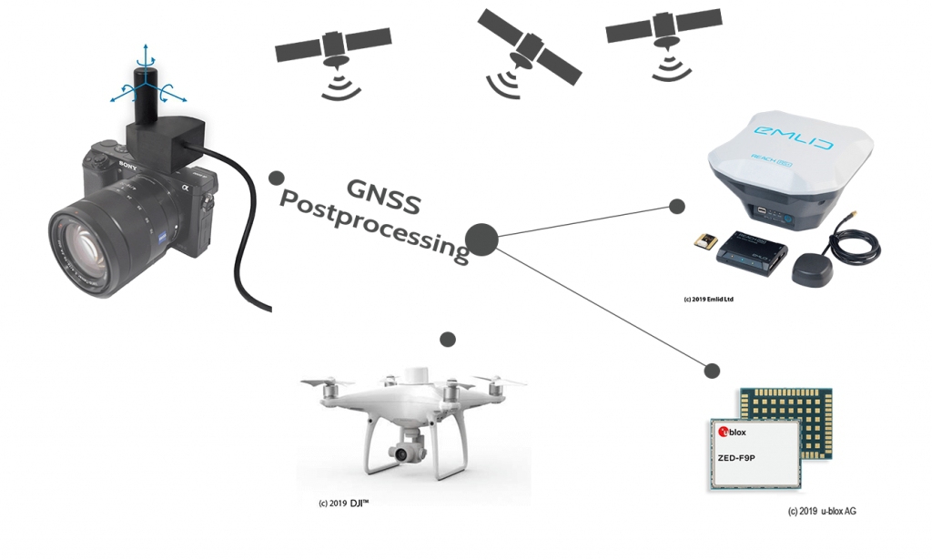
GNSS Postprocessing PPK and Geotagging Software

What is REDtoolbox software?

The software performs a multi-constellation (GPS, GLONASS, Beidou, Galileo) and multichannel (L1, L2, L5) GNSS postprocessing PPK of Base-Rover configurations. Such configurations can be found in many UAV / drone applications such as the Matrice 300 RTK and Phantom 4 RTK. The corrected GNSS path accuracy is at centimeter level, depending on the device use, the current satellite constellation and receipt quality.

Outputted as plain Text, as image EXIF data or in native Agisoft, Pix4d and Google Earth files, these information can be used many other fields of applications., eg. in photogrammetry and documentation.

When should you use REDtoolbox?

REDtoolbox is ideal, first, for acting as a back-up when a Network RTK service is not available, e.g. when cell service is poor, or when RTK connection is lost between the drone and base station during a flight, allowing you to achieve the accuracy you would with normal RTK corrections. REDtoolbox is also ideal for converting captured photos to a local coordinate system, by measuring the offset to GCPs measured locally. Most common photogrammetry software struggle to achieve this to a high accuracy level, especially for less common coordinate systems.

Product type: Software
Software licence: Unlimited (Lifetime) / Perpetual


Delivery content

1x REDtoolbox perpetual full license + Lifetime Updates + Support

Reviews
0

0 of 0 reviews

Average rating of 0 out of 5 stars

Leave a review!

Share your experiences with other customers.


Skip product gallery

Similar products

Tip
DJI Zenmuse P1 image 1_EPOTRONIC
DJI Zenmuse P1
DJI Zenmuse P1 Der neue Standard für Vermessungen aus der Luft Die Zenmuse P1 umfasst einen Vollformat-Sensor mit austauschbaren Objektiven mit fester Brennweite auf ein ...
EMLID Aluminium Extension Pole 0.15m for Reach image 1_EPOTRONIC
Product Quantity: Enter the desired amount or use the buttons to increase or decrease the quantity.
EMLID Aluminium Extension Pole 0.15m for Reach
Emlid aluminum extension pole 0.15m for Reach RS2/RS2+/RS3 EXT-POLE-EMLID Länge 150 mm ...
€53.55*
GREENVALLEY LiAir X3C-H + Camera + LiGeoreference image 1_EPOTRONIC
Product Quantity: Enter the desired amount or use the buttons to increase or decrease the quantity.
GREENVALLEY LiAir X3C-H + Camera + LiGeoreference
GREENVALLEY LiAir X3C-H + Camera + LiGeoreference Genauigkeitsbereich: ± 2cm (1σ@20m) Gewicht: 1.25kg (einschl. Kamera) Scanbereich: 190m @ 10% Reflexionsgrad 450m @ 80% ...
€17,906.67*
EPOTRONIC - Theory - Basics of UAV surveying - pro Mitarbeiter image 1_EPOTRONIC
Product Quantity: Enter the desired amount or use the buttons to increase or decrease the quantity.
EPOTRONIC - Theory - Basics of UAV surveying - pro Mitarbeiter
Überblick Vermittlung der Grundlagen für die UAV-gestützte Vermessung und damit verbundene Vermessungsaufgaben. Die Schulung umfasst sowohl die theoretischen Kenntnisse zu ...
€583.10*
EMLID Multi-Band GNSS Antenna for Reach M2 image 1_EPOTRONIC
Product Quantity: Enter the desired amount or use the buttons to increase or decrease the quantity.
EMLID Multi-Band GNSS Antenna for Reach M2
EMLID Multi-Band GNSS Antenna for Reach M2 ANT107 Multi-band helical GNSS antenna Tracks L1/L2 bands on GPS, GLONASS, BeiDou and E1/E5 on Galileo. ...
€272.51*
EMLID Reach RS3 (Multi-Band RTK GNSS Receiver) image 1_EPOTRONIC
Product Quantity: Enter the desired amount or use the buttons to increase or decrease the quantity.
EMLID Reach RS3 (Multi-Band RTK GNSS Receiver)
EMLID Reach RS3 (Multi-Band RTK GNSS Receiver) Zentimetergenaue Position Für Vermessung, Kartierung und Navigation Wird mit der Emlid Flow-App geliefert Baseline bis zu 1 ...
€2,973.81*
EPOTRONIC - Datenerhebung mittels GeoCue TrueView Go 116S + Datenprozessierung (1/2 Tag) image 1_EPOTRONIC
EPOTRONIC - Datenerhebung mittels GeoCue TrueView Go 116S + Datenprozessierung (1/2 Tag)
EPOTRONIC - Datenerhebung mittels GeoCue TrueView Go 116S + Datenprozessierung (1/2 Tag) Der Tagessatz umfasst den kompletten Prozess des handheld 3D-Laserscannings inklu ...
EMLID Reach M+ UAV Mapping Kit image 1_EPOTRONIC
Product Quantity: Enter the desired amount or use the buttons to increase or decrease the quantity.
EMLID Reach M+ UAV Mapping Kit
EMLID Reach M+ UAV Mapping Kit Package includes – Reach RS+ – Reach M+ – Tallysman multi-GNSS antenna – Camera hot shoe adapter (optional) – Carry case – Radio antenna – A ...
€1,662.43*
SHARE 304S Pro image 1_EPOTRONIC
SHARE 304S Pro
SHARE 304S Pro Die abgebildete Drohne ist nicht Teil des Lieferumfangs. Die SHARE 304S Pro ist eine professionelle Kartierungskamera, die für Luftaufnahmen und Kartierun ...
Emlid Scanning handle image 1_EPOTRONIC
Product Quantity: Enter the desired amount or use the buttons to increase or decrease the quantity.
Emlid Scanning handle
Emlid Scanning Griff Optimale Lösung zum Arbeiten mit dem Emlid Reach RX ...
€236.81*
EMLID Reach M2 UAV Mapping Kit image 1_EPOTRONIC
Product Quantity: Enter the desired amount or use the buttons to increase or decrease the quantity.
EMLID Reach M2 UAV Mapping Kit
EMLID Reach M2 UAV Mapping Kit Package includes – Reach RS2 – Reach M2 – Multi-band GNSS antenna – Reach M+/M2 SMA antenna adapter cable 0.5m – Camera hot shoe adapter (o ...
€3,922.24*
SHARE 100M Pro image 1_EPOTRONIC
SHARE 100M Pro
SHARE 100M Pro Die abgebildete Drohne ist nicht Teil des Lieferumfangs. Der SHARE 100M Pro ist eine Vermessungskamera für Drohnen, die mit einem Mittelformatsensor von 4 ...


Ihre Fragen direkt beantwortet: