

How to Use Drones for BIM Workflows and Producing Digital Twins
On this page, we talk you through and show you exactly what you need to utilise UAV's in to your surveying workflow. From how to capture the data, through to the final product, we aim to make it as simple as possible.
Contents
Introduction
This page displays some of the potential use cases of drones, and how they can benefit companies working, or wanting to work, with BIM and Digital Twins. We describe what BIM and Digital Twins are, for those who don’t already know, then delve into the solutions. The main solutions consist of sensors such as the DJI Zenmuse L1 and P1, which mount to the Matrice 300 RTK (M300 RTK), and the Phantom 4 RTK (P4RTK). These solutions come in at around €15 000 to € 20 000 with the M300 RTK, the most capable enterprise drone from DJI, and around €5000 for the P4RTK, all of which provide surveyor-level accuracy. However, for those keen to utilise drones for their projects with lower upfront costs, they can with drones costing less than €2000. These can provide very good results, although not at the resolution, accuracy or efficiency as that of the higher-end solutions.

What is BIM and what is a Digital Twin?
BIM and Digital Twin are two terms that are widely used these days in the world of modern technologies, claimed as game-changing solutions for a wide range of industries. But before we get into the details of how these technologies can be used in combination with drones, what do BIM and Digital Twin actually mean?
BIM
The concept of BIM (Building Information Modelling) is no different to a set of 2D drawings and a specification document. It is used for creating and managing data during the lifecycle of a building project, from planning, design, construction and post-built monitoring and maintenance. BIM integrates data from multiple sources to create detailed digital models that are available in an open-cloud environment for real-time collaboration between stakeholders.
BIM informs project planning by generating in-context models of the existing environment where designs can be added. During the design phase, BIM data is used to inform scheduling and logistics. Then, construction begins by using BIM specifications. Schedules are shared with trades and contractors to improve efficiency and shorten project delivery time. In the post-built phase, BIM still offers value by informing cost-effective renovation works. Overall, BIM informs decision making, gives greater visibility and more sustainable options, which can all come together to provide cost savings for the project.
Some specific applications possible with BIM:
- Mass modelling
- Risk analysis
- Cost estimation
- Logistics
- Testing model performance
- Sustainability analysis
- Energy analysis
- Structural analysis
- Coordination
- Planned maintenance
BIM aims to benefit industries by:
- Reducing construction costs and project delivery time
- Reducing long term operating costs for infrastructure
- Helping meet carbon reduction targets
- Ensuring construction companies stay competitive on the global market
Digital Twin
A digital twin does not contain the wide range of information found in a BIM. It is more simply a realistic representation of something physical, with associated spatial information. However, like a BIM, it is made accessible and interactive. It’s name derives from the fact that it is an exact counterpart to the physical object. It is also updated with real-time data from sensors on the object, so that it remains a true ‘twin’. This shows engineers not just how the product is performing, but how it would perform in certain scenarios through running simulations.
Digital twins also are said to be game-changing. Forward-thinkers imagine a world where whole cities are digitally represented. This would enable users to search digital space like in a word document, for example searching for a bench near a river that is in the sun. This world will also be visible to AI, which opens up a magnitude of possible technological opportunities, for such things as driverless cars and ‘Smart Cities”.
.jpg)
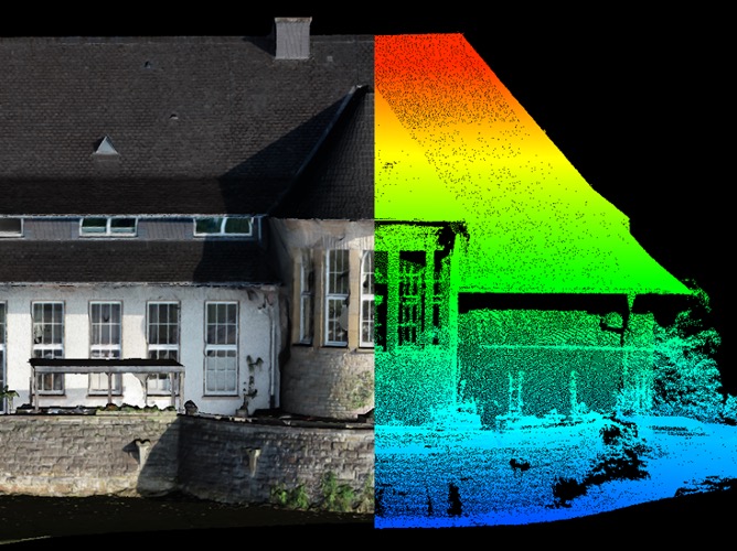
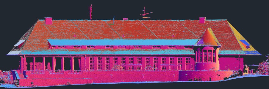
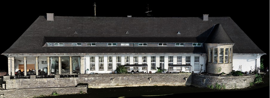
The data that creates BIMs and Digital Twins can be captured from essentially any source that can record georeferenced spatial information. As you can read in our other article “Traditional Surveying vs Drone Surveying”, we show that by using drones, either utilising photogrammetry or LiDAR, topographic surveys can be completed in significantly less time compared to traditional techniques. Combined with equipment cost savings, the total cost is significantly lower. This relationship would be even more pronounced for building and asset surveys, which take more effort to survey by traditional means.
Drones can, of course, capture detail from above, capturing areas that may simply be impossible to capture using traditional techniques, e.g. GNSS rover, total station detailing, or terrestrial laser scanning (TLS). Consequently, the dataset is more ‘full’; almost every visible part of the object can be captured, rather than having only recorded a few points, and extrapolating in between.
Additionally the data can be seamlessly processed and imported into software capable of handling BIMs and Digital Twins.
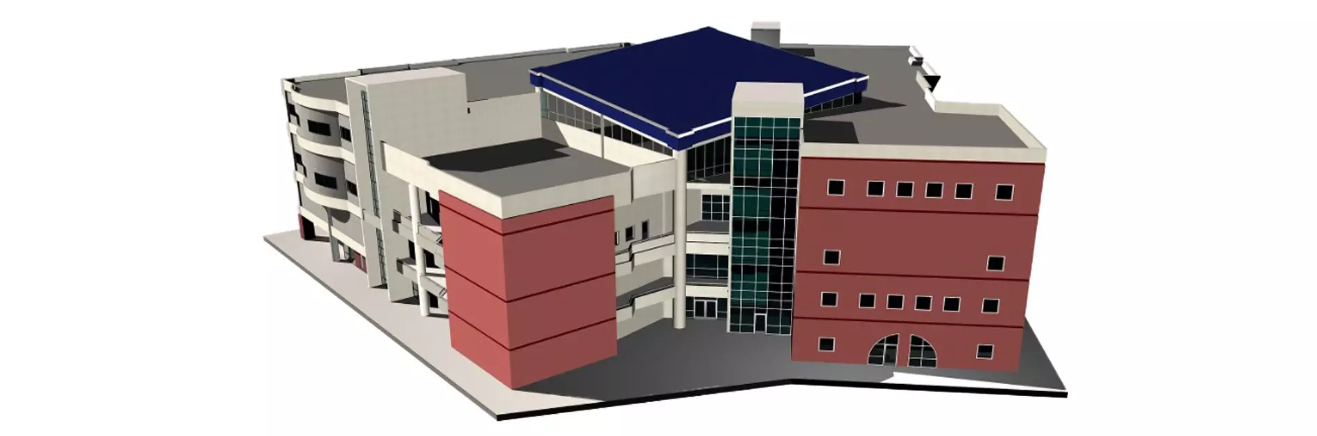
So, how can drones actually be used to make BIMs and Digital Twins? Fortunately, the solution is simple thanks to hardware and software options from DJI, and other software solutions such as AutoCAD, Leica Infinity, SketchUp and others.
The BIM process usually starts with surveying the environment before the construction has begun. Building models made using CAD tools can then be placed in the real world environment. Later, as-built surveys can be performed, which can compare the design to the real-world object. BIM can also be undertaken on already existing buildings, which can be beneficial for renovation works that need to be undertaken.
DJI have multiple drone platforms and payloads capable of capturing data for these products. The Zenmuse L1 and P1 are the current flagship payloads from DJI, which are compatible with DJI’s flagship enterprise drone: the Matrice 300 RTK (M300 RTK). The Zenmuse P1’s 45MP 1” CMOS sensor is DJI’s highest resolution RGB sensor, suitable for highly detailed photogrammetry surveys. DJI report the P1 to be capable of achieving an absolute accuracy of 3cm in the horizontal axis and 5cm in the vertical axis. This was measured from results generated from photos with a 3 cm Ground Sampling Distance (GSD). However, test flights conducted by Epotronic found that, when flying at 50m altitude (AGL), which provides a GSD of 0.63 cm, accuracies of 1-2 cm were achieved in the horizontal and vertical axes in DJI Terra.
The Zenmuse L1 is DJI’s first lidar sensor, which is officially capable of achieving a horizontal and vertical absolute accuracy of 10 cm and 5 cm, respectively, is also an attractive solution. However, in tests conducted by Epotronic we measured vertical absolute accuracy as 2.1 cm from a 50 m AGL flight, and 5.1 cm from a 100 m AGL flight, along with vertical precision of +/- 3 to 5 cm, and +/- 7 to 11 cm, respectively. Despite the lower accuracy of the L1 compared to the P1, the LiDAR sensor holds advantages over the RGB solution, such as being able to work in low- or no-light, lower processing requirements and data storage, and the ability to capture detail behind some objects, e.g. glass or trees.
The Phantom 4 RTK (P4RTK) is also capable of generating data for BIM and digital twins. It utilises an RGB sensor like the P1, although is of lower resolution. This means it must be flown closer to capture comparable resolution, and is therefore less time efficient. However, it can still capture sufficient detail and at high accuracy thanks to its RTK module, achieving horizontal and vertical absolute accuracy of approximately 2 cm.


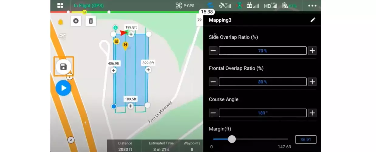
There are multiple apps and mission modes that are available for users that would like to capture data suitable for BIMs and Digital Twins. To start off, DJI have apps integrated with the remote controller for the M300 and P4RTK that can perform multiple suitable mission modes, DJI Pilot and DJI GS RTK, respectively.
Regular top-down surveying missions are simple and capable of capturing sufficient data. The general flight path usually consists of parallel flight strips, or flight strips that make up a grid pattern. Flying with the camera pointed at an oblique angle rather than straight down is recommended, as it allows more detail on the sides of objects to be captured. This is known as oblique mode. The P1 even comes with a ‘Smart Oblique’ feature that significantly increases the efficiency compared to a standard oblique mission by intelligently varying flight speed and camera angle throughout the flight. This will also reduce the processing time and requirements as less photos are captured.
With the P4RTK, users can use the Angled Flight Route mode, to undertake flights capturing the vertical faces of buildings. The flight plan is simple to set up, requiring a short manual flight for each face to mark the boundaries.
We at Epotronic would also recommend capturing photos of the corners of the building manually to maximise the accuracy of the model. A video showcasing this mode can be viewed at the following link:
Watch Angled Flight Route video here
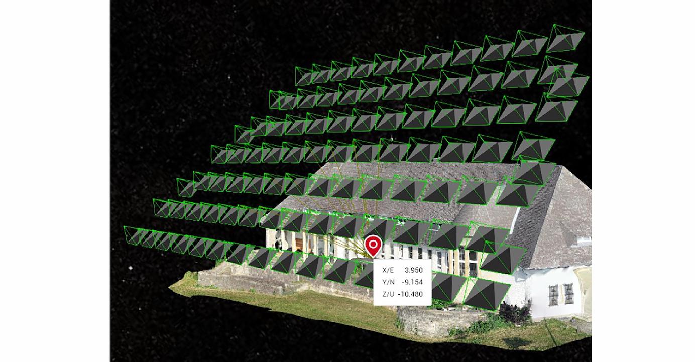
When using these sensors, 3rd party planning software can also be used, which include planning modes that are specifically designed for building surveys. With UgCS, one of the biggest flight planning software programmes, users can perform a wide variety of flight modes, and it offers more freedom to position waypoints, visible from a 3D view. It also has a specific mode for façade survey.. A KML model can be imported, and the perimeter of the survey can be simply drawn around it, so that the drone captures a detailed view of all sides of the object of interest. As the drone is closer, the model, once generated, will be much higher resolution than from a regular above-view flight.
Another 3rd party programme, WayPoint Master, has all of the flexibility of UgCS, and also includes cutting-edge flight routes and a facade survey, that allows more complex routes to be drawn around importable models. These models could be made, for example from an oblique flight, and processed in DJI Terra to be imported into WayPoint Master.
For the highest accuracy, the user should be using a form of differential GNSS to correct the positional data captured by the sensors. This could be from a local base station, such as the D-RTK 2 Mobile Station, or using a Network RTK service, such as SAPOS in Germany.
The processing software
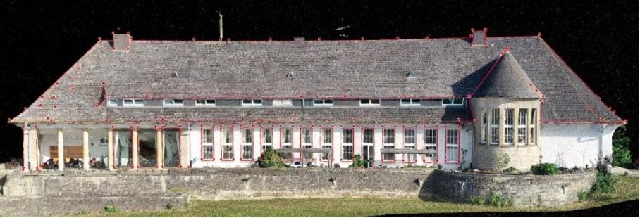
DJI Terra is able to process the data from the L1, P1 and P4RTK into usable products for BIM and Digital twins. For the P1 and P4RTK the process is the same: using photogrammetry techniques to stitch together the photos into a 3D georeferenced point cloud, and thereafter an optional 3D model. If multiple flight missions were performed, as is likely with the P4RTK using the Angled Flight Route, these can all be put together into a single project. The processing is automatic, the user must only select a few reconstruction settings, and mark ground control points (GCPs). The same is true with the L1, which also does not require GCP marking, allowing results to be generated in minutes.
These data can be exported from DJI Terra in common file formats, for point clouds, these can be exported as LAS files for example. Exporting the point clouds allows seamless import into programmes specifically designed to work with BIM products, such as AutoCAD Revit. From these point clouds the models can be drawn and filled with relevant information, ready for use.
BIM and Digital Twins are two concepts that have the potential to transform industries, particularly in construction. BIMs allow for greater understanding, decision making, visibility and transparency, and prediction for building projects, which should reduce costs over the project life cycle. Generating digital twins allows for virtual maintenance and modelling, again increasing efficiency and cutting costs.
Drones with sensors such as P1, L1 and P4RTK can capture highly accurate data of the building or object and surrounding environment, using a variety of flight planning apps, and software such as DJI Terra for processing. Drones can also capture almost every detail of the target object that traditional techniques would likely miss, providing complete coverage: perfect for a Digital Twin or BIM.
To browse the solutions described here and more, please visit our online store at store.epotronic.com, where you can also find lots of relevant information in our blog.
If you would like to get in touch with any questions or queries, please don’t hesitate to get in touch at info@epotronic.com.